

Col de Vent, Aragon Espagne.
A cycling route starting in Castigaleu, Aragon, Spain.
Overview
About this route
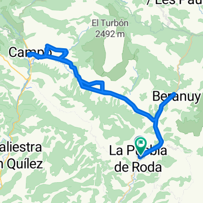
Beautiful route ridden from Camping Isàbena, Puebla de Roda.
- -:--
- Duration
- 37.5 km
- Distance
- 801 m
- Ascent
- 801 m
- Descent
- ---
- Avg. speed
- ---
- Max. altitude

Continue with Bikemap
Use, edit, or download this cycling route
You would like to ride Col de Vent, Aragon Espagne. or customize it for your own trip? Here is what you can do with this Bikemap route:
Free features
- Save this route as favorite or in collections
- Copy & plan your own version of this route
- Sync your route with Garmin or Wahoo
Premium features
Free trial for 3 days, or one-time payment. More about Bikemap Premium.
- Navigate this route on iOS & Android
- Export a GPX / KML file of this route
- Create your custom printout (try it for free)
- Download this route for offline navigation
Discover more Premium features.
Get Bikemap PremiumFrom our community
Other popular routes starting in Castigaleu
 BTT 14 Col de Vent , Cajigar
- Distance
- 36.1 km
- Ascent
- 1,085 m
- Descent
- 1,085 m
- Location
- Castigaleu, Aragon, Spain
 Estall i Montfalcó
- Distance
- 55.3 km
- Ascent
- 1,718 m
- Descent
- 1,713 m
- Location
- Castigaleu, Aragon, Spain
 Route nach Diseminado Puebla de Roda
- Distance
- 62 km
- Ascent
- 1,082 m
- Descent
- 1,136 m
- Location
- Castigaleu, Aragon, Spain
 BTT route 12 Esdolomada Guël
- Distance
- 29.9 km
- Ascent
- 682 m
- Descent
- 684 m
- Location
- Castigaleu, Aragon, Spain
 puente montañana circular pueblos
- Distance
- 86 km
- Ascent
- 1,742 m
- Descent
- 1,727 m
- Location
- Castigaleu, Aragon, Spain
 vuelta al coll d'espina-fades
- Distance
- 95 km
- Ascent
- 1,781 m
- Descent
- 1,773 m
- Location
- Castigaleu, Aragon, Spain
 Tag 7
Tag 7- Distance
- 199.3 km
- Ascent
- 3,251 m
- Descent
- 2,820 m
- Location
- Castigaleu, Aragon, Spain
 Portugalia 2014 - dzień 28.
- Distance
- 120.9 km
- Ascent
- 1,059 m
- Descent
- 1,055 m
- Location
- Castigaleu, Aragon, Spain
Open it in the app