

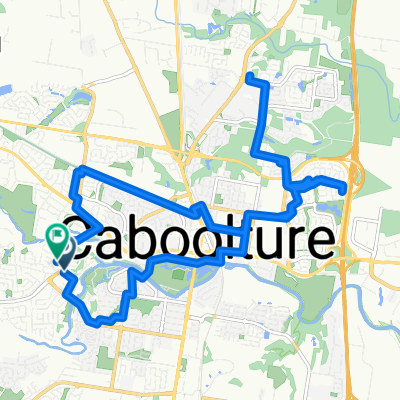
Caboolture-Sandgate Loop
A cycling route starting in Caboolture South, Queensland, Australia.
Overview
About this route
A loop taking in Morayfield, Burpengary, Redcliffe and Sandgate.
- -:--
- Duration
- 88.7 km
- Distance
- 105 m
- Ascent
- 107 m
- Descent
- ---
- Avg. speed
- ---
- Max. altitude
Route quality
Waytypes & surfaces along the route
Waytypes
Road
26.6 km
(30 %)
Cycleway
18.6 km
(21 %)
Surfaces
Paved
83.4 km
(94 %)
Asphalt
68.3 km
(77 %)
Concrete
15.1 km
(17 %)
Undefined
5.3 km
(6 %)
Continue with Bikemap
Use, edit, or download this cycling route
You would like to ride Caboolture-Sandgate Loop or customize it for your own trip? Here is what you can do with this Bikemap route:
Free features
- Save this route as favorite or in collections
- Copy & plan your own version of this route
- Split it into stages to create a multi-day tour
- Sync your route with Garmin or Wahoo
Premium features
Free trial for 3 days, or one-time payment. More about Bikemap Premium.
- Navigate this route on iOS & Android
- Export a GPX / KML file of this route
- Create your custom printout (try it for free)
- Download this route for offline navigation
Discover more Premium features.
Get Bikemap PremiumFrom our community
Other popular routes starting in Caboolture South
 Easy ride in Caboolture
- Distance
- 4.4 km
- Ascent
- 70 m
- Descent
- 77 m
- Location
- Caboolture South, Queensland, Australia
 Bribie Wam Loop
- Distance
- 85.3 km
- Ascent
- 198 m
- Descent
- 199 m
- Location
- Caboolture South, Queensland, Australia
 Bellmere Road to Crebra Court
- Distance
- 23.8 km
- Ascent
- 64 m
- Descent
- 65 m
- Location
- Caboolture South, Queensland, Australia
 Caboolture to Redcliffe
- Distance
- 93.8 km
- Ascent
- 172 m
- Descent
- 175 m
- Location
- Caboolture South, Queensland, Australia
 Route to 26 Christine Street, Caboolture
- Distance
- 7.1 km
- Ascent
- 20 m
- Descent
- 19 m
- Location
- Caboolture South, Queensland, Australia
 High-speed route
- Distance
- 7.2 km
- Ascent
- 10 m
- Descent
- 6 m
- Location
- Caboolture South, Queensland, Australia
 Jeffreys Street 14, Caboolture South to Jeffreys Street 14, Caboolture South
- Distance
- 74.9 km
- Ascent
- 354 m
- Descent
- 353 m
- Location
- Caboolture South, Queensland, Australia
 Cattle Dr, Caboolture South to Dickson Rd, Caboolture South
- Distance
- 7.4 km
- Ascent
- 22 m
- Descent
- 19 m
- Location
- Caboolture South, Queensland, Australia
Open it in the app