

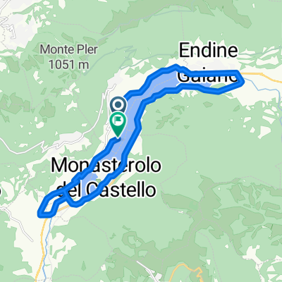
dzień 48
A cycling route starting in Ranzanico, Lombardy, Italy.
Overview
About this route
2014
- -:--
- Duration
- 94.3 km
- Distance
- 1,359 m
- Ascent
- 321 m
- Descent
- ---
- Avg. speed
- ---
- Max. altitude

Continue with Bikemap
Use, edit, or download this cycling route
You would like to ride dzień 48 or customize it for your own trip? Here is what you can do with this Bikemap route:
Free features
- Save this route as favorite or in collections
- Copy & plan your own version of this route
- Split it into stages to create a multi-day tour
- Sync your route with Garmin or Wahoo
Premium features
Free trial for 3 days, or one-time payment. More about Bikemap Premium.
- Navigate this route on iOS & Android
- Export a GPX / KML file of this route
- Create your custom printout (try it for free)
- Download this route for offline navigation
Discover more Premium features.
Get Bikemap PremiumFrom our community
Other popular routes starting in Ranzanico
 2019-4 Lago di Idro
- Distance
- 96.2 km
- Ascent
- 1,031 m
- Descent
- 975 m
- Location
- Ranzanico, Lombardy, Italy
 dzień 48
- Distance
- 94.3 km
- Ascent
- 1,359 m
- Descent
- 321 m
- Location
- Ranzanico, Lombardy, Italy
 Via San Giorgio nach Via San Giorgio
- Distance
- 19.5 km
- Ascent
- 478 m
- Descent
- 477 m
- Location
- Ranzanico, Lombardy, Italy
 Da Piazza Monte San Michele 1, Endine Gaiano a Via Carlo Ceresa 2M, Bergamo
- Distance
- 41.9 km
- Ascent
- 2,714 m
- Descent
- 2,740 m
- Location
- Ranzanico, Lombardy, Italy
 Gandino a Sovere
- Distance
- 5.7 km
- Ascent
- 665 m
- Descent
- 248 m
- Location
- Ranzanico, Lombardy, Italy
 25_I Rund um den Lago die Endine
- Distance
- 17.4 km
- Ascent
- 179 m
- Descent
- 180 m
- Location
- Ranzanico, Lombardy, Italy
Open it in the app