

Bähnleradweg
A cycling route starting in Grafenhausen, Baden-Wurttemberg, Germany.
Overview
About this route
TEASI track from 04.10.2014
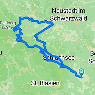
From Rothaus Camping via Seebrugg to Schluchsee and then on via Altglashütten to Bärental , and from there downhill via Bruderhalde to Tititsee-Neustadt. From here, the route continues on the Bähnleradweg through Lenzkirch to Bonndorf and via Sommerau to Faulenfürst , passing the Baden State Brewery Rothaus back to the campsite.- -:--
- Duration
- 72 km
- Distance
- 619 m
- Ascent
- 620 m
- Descent
- ---
- Avg. speed
- ---
- Max. altitude

Route quality
Waytypes & surfaces along the route
Waytypes
Track
24.5 km
(34 %)
Path
15.8 km
(22 %)
Surfaces
Paved
43.9 km
(61 %)
Unpaved
22.3 km
(31 %)
Asphalt
43.2 km
(60 %)
Loose gravel
13 km
(18 %)
Continue with Bikemap
Use, edit, or download this cycling route
You would like to ride Bähnleradweg or customize it for your own trip? Here is what you can do with this Bikemap route:
Free features
- Save this route as favorite or in collections
- Copy & plan your own version of this route
- Sync your route with Garmin or Wahoo
Premium features
Free trial for 3 days, or one-time payment. More about Bikemap Premium.
- Navigate this route on iOS & Android
- Export a GPX / KML file of this route
- Create your custom printout (try it for free)
- Download this route for offline navigation
Discover more Premium features.
Get Bikemap PremiumFrom our community
Other popular routes starting in Grafenhausen
 Schwarzwald 3
- Distance
- 51.1 km
- Ascent
- 380 m
- Descent
- 1,027 m
- Location
- Grafenhausen, Baden-Wurttemberg, Germany
 Bähnleradweg
- Distance
- 72 km
- Ascent
- 619 m
- Descent
- 620 m
- Location
- Grafenhausen, Baden-Wurttemberg, Germany
 Schlühüwanapark - Naturerlebnispfad
- Distance
- 3.8 km
- Ascent
- 67 m
- Descent
- 111 m
- Location
- Grafenhausen, Baden-Wurttemberg, Germany
 Schluchsee - Schluchsee Rundkurs
- Distance
- 33.3 km
- Ascent
- 355 m
- Descent
- 354 m
- Location
- Grafenhausen, Baden-Wurttemberg, Germany
 Route in Grafenhausen
- Distance
- 76.1 km
- Ascent
- 2,068 m
- Descent
- 2,066 m
- Location
- Grafenhausen, Baden-Wurttemberg, Germany
 Feldberggipfel
- Distance
- 50.3 km
- Ascent
- 788 m
- Descent
- 788 m
- Location
- Grafenhausen, Baden-Wurttemberg, Germany
 Schluchseerunde über Riesenbühl
- Distance
- 33.5 km
- Ascent
- 498 m
- Descent
- 497 m
- Location
- Grafenhausen, Baden-Wurttemberg, Germany
 RouteWT 10 - Zwei-Täler-Tour
- Distance
- 30 km
- Ascent
- 676 m
- Descent
- 679 m
- Location
- Grafenhausen, Baden-Wurttemberg, Germany
Open it in the app