

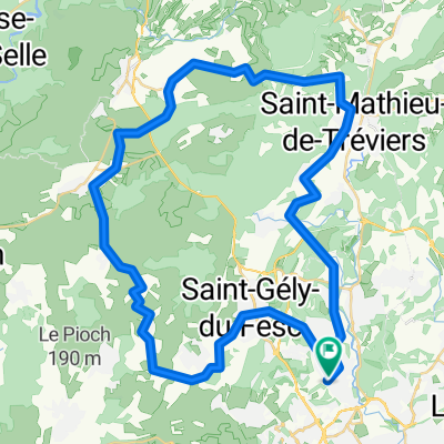
MUC_Balade Montferrier-sur-Lez, St-Mathieu-de-Tréviers, St-Bauzille-de-Montmel
A cycling route starting in Montferrier-sur-Lez, Occitanie, France.
Overview
About this route
MUC Cycling Ride
Montferrier-sur-Lez, St-Mathieu-de-Tréviers, St-Bauzille-de-Montmel, Teyran, Montferrier-sur-Lez
- -:--
- Duration
- 47 km
- Distance
- 271 m
- Ascent
- 271 m
- Descent
- ---
- Avg. speed
- ---
- Max. altitude
Route quality
Waytypes & surfaces along the route
Waytypes
Road
17.9 km
(38 %)
Quiet road
6.1 km
(13 %)
Surfaces
Paved
29.6 km
(63 %)
Asphalt
29.6 km
(63 %)
Undefined
17.4 km
(37 %)
Continue with Bikemap
Use, edit, or download this cycling route
You would like to ride MUC_Balade Montferrier-sur-Lez, St-Mathieu-de-Tréviers, St-Bauzille-de-Montmel or customize it for your own trip? Here is what you can do with this Bikemap route:
Free features
- Save this route as favorite or in collections
- Copy & plan your own version of this route
- Sync your route with Garmin or Wahoo
Premium features
Free trial for 3 days, or one-time payment. More about Bikemap Premium.
- Navigate this route on iOS & Android
- Export a GPX / KML file of this route
- Create your custom printout (try it for free)
- Download this route for offline navigation
Discover more Premium features.
Get Bikemap PremiumFrom our community
Other popular routes starting in Montferrier-sur-Lez
 Montpellier cn mi cosita
- Distance
- 17.2 km
- Ascent
- 93 m
- Descent
- 95 m
- Location
- Montferrier-sur-Lez, Occitanie, France
 tour pic st loup
- Distance
- 62.9 km
- Ascent
- 474 m
- Descent
- 471 m
- Location
- Montferrier-sur-Lez, Occitanie, France
 MUC_Balade Montferrier-sur-Lez, St-Mathieu-de-Tréviers, St-Bauzille-de-Montmel
- Distance
- 47 km
- Ascent
- 271 m
- Descent
- 271 m
- Location
- Montferrier-sur-Lez, Occitanie, France
 fdsfs
fdsfs- Distance
- 103.5 km
- Ascent
- 1,125 m
- Descent
- 1,132 m
- Location
- Montferrier-sur-Lez, Occitanie, France
 Samedi "Je te donne ma lumière"
- Distance
- 62.1 km
- Ascent
- 732 m
- Descent
- 726 m
- Location
- Montferrier-sur-Lez, Occitanie, France
 1st Montpellier tour
- Distance
- 49.6 km
- Ascent
- 345 m
- Descent
- 350 m
- Location
- Montferrier-sur-Lez, Occitanie, France
 vers Mazamet
- Distance
- 222.4 km
- Ascent
- 2,358 m
- Descent
- 2,132 m
- Location
- Montferrier-sur-Lez, Occitanie, France
 Montpellier-Salagou
- Distance
- 11.8 km
- Ascent
- 53 m
- Descent
- 140 m
- Location
- Montferrier-sur-Lez, Occitanie, France
Open it in the app