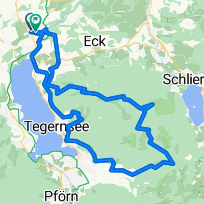
Drei - Seen Runde (Tegernsee-Spitzingsee-Schliersee)
A cycling route starting in Gmund am Tegernsee, Bavaria, Germany.
Overview
About this route
Technically not particularly demanding, but still a scenic loop. Depending on the choice of bike (road bike or MTB), you can adapt this tour to your own needs. There are plenty of alternatives running parallel to the main route. The ride is done counterclockwise. The entire route offers several opportunities to stop at a local inn. The most interesting part of the route is the Bockerlbahntrail (Waitzinger Alm - Fischhausen station).
- -:--
- Duration
- 50.4 km
- Distance
- 662 m
- Ascent
- 662 m
- Descent
- ---
- Avg. speed
- ---
- Max. altitude
Route quality
Waytypes & surfaces along the route
Waytypes
Quiet road
22.2 km
(44 %)
Track
15.1 km
(30 %)
Surfaces
Paved
36.8 km
(73 %)
Unpaved
10.6 km
(21 %)
Asphalt
36.8 km
(73 %)
Gravel
6.6 km
(13 %)
Route highlights
Points of interest along the route
Point of interest after 50.4 km
Start: Volksfestplatz
Continue with Bikemap
Use, edit, or download this cycling route
You would like to ride Drei - Seen Runde (Tegernsee-Spitzingsee-Schliersee) or customize it for your own trip? Here is what you can do with this Bikemap route:
Free features
- Save this route as favorite or in collections
- Copy & plan your own version of this route
- Sync your route with Garmin or Wahoo
Premium features
Free trial for 3 days, or one-time payment. More about Bikemap Premium.
- Navigate this route on iOS & Android
- Export a GPX / KML file of this route
- Create your custom printout (try it for free)
- Download this route for offline navigation
Discover more Premium features.
Get Bikemap PremiumFrom our community
Other popular routes starting in Gmund am Tegernsee
 Schwarze Tenn
- Distance
- 42.6 km
- Ascent
- 840 m
- Descent
- 835 m
- Location
- Gmund am Tegernsee, Bavaria, Germany
 Tegernsee Tour 1
- Distance
- 22.6 km
- Ascent
- 923 m
- Descent
- 923 m
- Location
- Gmund am Tegernsee, Bavaria, Germany
 Gmund - Huberspitz - Kreuzeck
- Distance
- 35.1 km
- Ascent
- 1,124 m
- Descent
- 1,126 m
- Location
- Gmund am Tegernsee, Bavaria, Germany
 Tegernsee - Schliersee
- Distance
- 48.5 km
- Ascent
- 325 m
- Descent
- 323 m
- Location
- Gmund am Tegernsee, Bavaria, Germany
 Tergernsee_Poll1
- Distance
- 23.4 km
- Ascent
- 131 m
- Descent
- 131 m
- Location
- Gmund am Tegernsee, Bavaria, Germany
 Kallenbach - Aueralm - Bad Wiessee - Kallenbach
- Distance
- 31.2 km
- Ascent
- 793 m
- Descent
- 793 m
- Location
- Gmund am Tegernsee, Bavaria, Germany
 Tegernseerundfahrt
- Distance
- 20.1 km
- Ascent
- 135 m
- Descent
- 134 m
- Location
- Gmund am Tegernsee, Bavaria, Germany
 Dürrnbach - Baumgartenschneid Runde
- Distance
- 38.9 km
- Ascent
- 1,261 m
- Descent
- 1,266 m
- Location
- Gmund am Tegernsee, Bavaria, Germany
Open it in the app


