

Lattenbergrunde
A cycling route starting in Schneizlreuth, Bavaria, Germany.
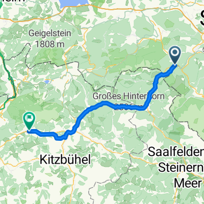
Overview
About this route
From Bad Reichenhall, take the Berchtesgadener road towards Bischofswiesen. Just before, turn right over Loipl (20%) to Schwarzeck and from there continue towards Hintersee. From Hintersee, via Wachtel to Unterjettenberg and past Saalachsee back to Bad Reichenhall.
- -:--
- Duration
- 49.6 km
- Distance
- 876 m
- Ascent
- 876 m
- Descent
- ---
- Avg. speed
- ---
- Max. altitude
Route quality
Waytypes & surfaces along the route
Waytypes
Road
15.9 km
(32 %)
Path
4 km
(8 %)
Surfaces
Paved
44.7 km
(90 %)
Unpaved
4 km
(8 %)
Asphalt
44.7 km
(90 %)
Gravel
2.5 km
(5 %)
Continue with Bikemap
Use, edit, or download this cycling route
You would like to ride Lattenbergrunde or customize it for your own trip? Here is what you can do with this Bikemap route:
Free features
- Save this route as favorite or in collections
- Copy & plan your own version of this route
- Sync your route with Garmin or Wahoo
Premium features
Free trial for 3 days, or one-time payment. More about Bikemap Premium.
- Navigate this route on iOS & Android
- Export a GPX / KML file of this route
- Create your custom printout (try it for free)
- Download this route for offline navigation
Discover more Premium features.
Get Bikemap PremiumFrom our community
Other popular routes starting in Schneizlreuth
 Reiteralpe Hintersee 8er Runde
- Distance
- 72.8 km
- Ascent
- 2,485 m
- Descent
- 2,485 m
- Location
- Schneizlreuth, Bavaria, Germany
 Rund um die Reiteralpe CLONED FROM ROUTE 322882
- Distance
- 51.7 km
- Ascent
- 1,617 m
- Descent
- 1,617 m
- Location
- Schneizlreuth, Bavaria, Germany
 BAUMGARTEN-VOGELSPITZ-WACHTERL
- Distance
- 22.1 km
- Ascent
- 935 m
- Descent
- 933 m
- Location
- Schneizlreuth, Bavaria, Germany
 Lattenbergrunde
- Distance
- 49.6 km
- Ascent
- 876 m
- Descent
- 876 m
- Location
- Schneizlreuth, Bavaria, Germany
 Tag 3: Schneizlreuth - Scheffau
- Distance
- 58.5 km
- Ascent
- 1,137 m
- Descent
- 956 m
- Location
- Schneizlreuth, Bavaria, Germany
 Rund um den Hochkönig
- Distance
- 167.8 km
- Ascent
- 1,295 m
- Descent
- 1,299 m
- Location
- Schneizlreuth, Bavaria, Germany
 Reiteralpe mit Abstecher zur Litzlalm
- Distance
- 53.7 km
- Ascent
- 1,668 m
- Descent
- 1,668 m
- Location
- Schneizlreuth, Bavaria, Germany
 Rund um die Reiteralm 2
- Distance
- 54.1 km
- Ascent
- 1,746 m
- Descent
- 1,744 m
- Location
- Schneizlreuth, Bavaria, Germany
Open it in the app