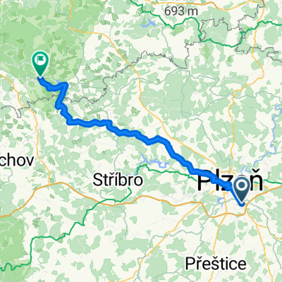
Plzeň - Těnovice - Blovice a zpět
A cycling route starting in Starý Plzenec, Plzeň Region, Czechia.
Overview
About this route
to the only Buddhist stupa in the Czech Republic
- -:--
- Duration
- 63.8 km
- Distance
- 713 m
- Ascent
- 683 m
- Descent
- ---
- Avg. speed
- ---
- Max. altitude
Route quality
Waytypes & surfaces along the route
Waytypes
Road
42.8 km
(67 %)
Track
11.5 km
(18 %)
Surfaces
Paved
24.3 km
(38 %)
Unpaved
5.7 km
(9 %)
Asphalt
21.7 km
(34 %)
Gravel
3.8 km
(6 %)
Continue with Bikemap
Use, edit, or download this cycling route
You would like to ride Plzeň - Těnovice - Blovice a zpět or customize it for your own trip? Here is what you can do with this Bikemap route:
Free features
- Save this route as favorite or in collections
- Copy & plan your own version of this route
- Sync your route with Garmin or Wahoo
Premium features
Free trial for 3 days, or one-time payment. More about Bikemap Premium.
- Navigate this route on iOS & Android
- Export a GPX / KML file of this route
- Create your custom printout (try it for free)
- Download this route for offline navigation
Discover more Premium features.
Get Bikemap PremiumFrom our community
Other popular routes starting in Starý Plzenec
- Starý Plzenec - Padrťské rybníky
- Distance
- 72.4 km
- Ascent
- 637 m
- Descent
- 637 m
- Location
- Starý Plzenec, Plzeň Region, Czechia
- Letkov - Chodov 1
- Distance
- 96 km
- Ascent
- 731 m
- Descent
- 711 m
- Location
- Starý Plzenec, Plzeň Region, Czechia
- bike tour through Plzeň
- Distance
- 12.2 km
- Ascent
- 124 m
- Descent
- 226 m
- Location
- Starý Plzenec, Plzeň Region, Czechia
- SP-M-1
- Distance
- 93.8 km
- Ascent
- 550 m
- Descent
- 465 m
- Location
- Starý Plzenec, Plzeň Region, Czechia
- Plzenec - Letkovský lom, D5, Olympia, Radyně, Sedlecké rybníky
- Distance
- 18 km
- Ascent
- 458 m
- Descent
- 458 m
- Location
- Starý Plzenec, Plzeň Region, Czechia
- Okruh kolem Radyně
- Distance
- 12.9 km
- Ascent
- 375 m
- Descent
- 375 m
- Location
- Starý Plzenec, Plzeň Region, Czechia
- Plzenec - Letkovský lom, D5, Olympia, Radyně, Sedlecké rybníky
- Distance
- 18.8 km
- Ascent
- 441 m
- Descent
- 444 m
- Location
- Starý Plzenec, Plzeň Region, Czechia
- Mokrouše-Raková-Mirošov-Hádky-Mokrouše
- Distance
- 26.8 km
- Ascent
- 353 m
- Descent
- 352 m
- Location
- Starý Plzenec, Plzeň Region, Czechia
Open it in the app