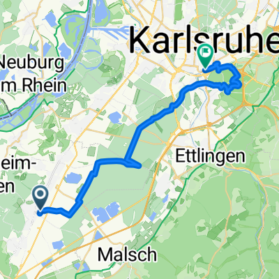
Bietigheim - Iffezheim - Neuburg
A cycling route starting in Bietigheim, Baden-Württemberg, Germany.
Overview
About this route
Von Bietigheim nach Iffezheim, über den Rhein. Dann am Rhein entlang nach Neuburg. Dort mit der Fähre wieder auf die badische Seite und zurück nach Bietigheim.
- -:--
- Duration
- 52.7 km
- Distance
- 9 m
- Ascent
- 8 m
- Descent
- ---
- Avg. speed
- ---
- Avg. speed
Route quality
Waytypes & surfaces along the route
Waytypes
Track
20.8 km
(39 %)
Busy road
7.1 km
(13 %)
Surfaces
Paved
43.7 km
(83 %)
Unpaved
6.4 km
(12 %)
Asphalt
36.8 km
(70 %)
Paved (undefined)
6.5 km
(12 %)
Continue with Bikemap
Use, edit, or download this cycling route
You would like to ride Bietigheim - Iffezheim - Neuburg or customize it for your own trip? Here is what you can do with this Bikemap route:
Free features
- Save this route as favorite or in collections
- Copy & plan your own version of this route
- Sync your route with Garmin or Wahoo
Premium features
Free trial for 3 days, or one-time payment. More about Bikemap Premium.
- Navigate this route on iOS & Android
- Export a GPX / KML file of this route
- Create your custom printout (try it for free)
- Download this route for offline navigation
Discover more Premium features.
Get Bikemap PremiumFrom our community
Other popular routes starting in Bietigheim
- Bietigheim Steinmauern
- Distance
- 16.3 km
- Ascent
- 26 m
- Descent
- 30 m
- Location
- Bietigheim, Baden-Württemberg, Germany
- Stadtradeln: RS13 - Blau gegen Gelb
- Distance
- 12.9 km
- Ascent
- 20 m
- Descent
- 21 m
- Location
- Bietigheim, Baden-Württemberg, Germany
- [Planung] RS13 KA-RA Durchfahrt Durmersheim Variante gelb
- Distance
- 4.4 km
- Ascent
- 0 m
- Descent
- 4 m
- Location
- Bietigheim, Baden-Württemberg, Germany
- 4-Gipfel Tour
- Distance
- 53.1 km
- Ascent
- 1,104 m
- Descent
- 1,108 m
- Location
- Bietigheim, Baden-Württemberg, Germany
- Bietigheim-Ebersteinburg-Schloss-Hohenbaden-Bietigheim
- Distance
- 59.5 km
- Ascent
- 440 m
- Descent
- 439 m
- Location
- Bietigheim, Baden-Württemberg, Germany
- Ausfahrt durch Bietigheim
- Distance
- 16.7 km
- Ascent
- 16 m
- Descent
- 14 m
- Location
- Bietigheim, Baden-Württemberg, Germany
- Bietigheim-KA durch den Hardtwald
- Distance
- 23.1 km
- Ascent
- 12 m
- Descent
- 8 m
- Location
- Bietigheim, Baden-Württemberg, Germany
- [Planung] RS13 KA-RA Durchfahrt Durmersheim Variante rot
- Distance
- 3.8 km
- Ascent
- 13 m
- Descent
- 12 m
- Location
- Bietigheim, Baden-Württemberg, Germany
Open it in the app