

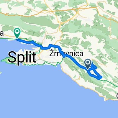
Sitno - Dubrava - Gata - Ostrvica
A cycling route starting in Srinjine, Split-Dalmatia County, Croatia.
Overview
About this route
Polazak je Sirotkovića, prvih 2 km prema Dubravi je uspon oko 4-6%, poslje je se relativno ravno, sve dok se ne dođe do kraja Dubrave (čotići). Od tuda je makadam sve i oko 3 km uspon, a nakon toga spust do Gata (Skoćiba).
- -:--
- Duration
- 36.1 km
- Distance
- 687 m
- Ascent
- 687 m
- Descent
- ---
- Avg. speed
- ---
- Max. altitude

Continue with Bikemap
Use, edit, or download this cycling route
You would like to ride Sitno - Dubrava - Gata - Ostrvica or customize it for your own trip? Here is what you can do with this Bikemap route:
Free features
- Save this route as favorite or in collections
- Copy & plan your own version of this route
- Sync your route with Garmin or Wahoo
Premium features
Free trial for 3 days, or one-time payment. More about Bikemap Premium.
- Navigate this route on iOS & Android
- Export a GPX / KML file of this route
- Create your custom printout (try it for free)
- Download this route for offline navigation
Discover more Premium features.
Get Bikemap PremiumFrom our community
Other popular routes starting in Srinjine
 Poljičke kneževine 43, Srinjine nach Poljičke kneževine 43, Srinjine
- Distance
- 55.3 km
- Ascent
- 605 m
- Descent
- 602 m
- Location
- Srinjine, Split-Dalmatia County, Croatia
 Stomorica - Stara Podstrana - Sv. Jure - Zrnovnica
- Distance
- 39.4 km
- Ascent
- 886 m
- Descent
- 886 m
- Location
- Srinjine, Split-Dalmatia County, Croatia
 Cool!
Cool!- Distance
- 42.4 km
- Ascent
- 1,056 m
- Descent
- 1,056 m
- Location
- Srinjine, Split-Dalmatia County, Croatia
 Gušti su Gušti
- Distance
- 23 km
- Ascent
- 196 m
- Descent
- 826 m
- Location
- Srinjine, Split-Dalmatia County, Croatia
 ride from Srinjine to
- Distance
- 30.3 km
- Ascent
- 602 m
- Descent
- 781 m
- Location
- Srinjine, Split-Dalmatia County, Croatia
 Zakon
Zakon- Distance
- 41.2 km
- Ascent
- 812 m
- Descent
- 812 m
- Location
- Srinjine, Split-Dalmatia County, Croatia
 Nediljni đir
- Distance
- 7.1 km
- Ascent
- 562 m
- Descent
- 563 m
- Location
- Srinjine, Split-Dalmatia County, Croatia
 Mosor 2018 - PD Bundek
- Distance
- 16.7 km
- Ascent
- 922 m
- Descent
- 922 m
- Location
- Srinjine, Split-Dalmatia County, Croatia
Open it in the app