

1ª Etapa Bicicleta 2015
A cycling route starting in Hendaye, Nouvelle-Aquitaine, France.
Overview
About this route
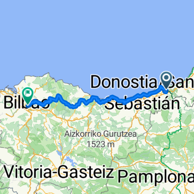
Start: Fuenterrabía
KM 0: N-638, at the airport level
Category 3 climb: Altzo
Category 3 climb: Abaltzisketa
Category 2 climb: Gaintza
Category 2 climb: Lazkaomendi
Category 1 climb: Alto de Aztiria
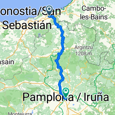
Intermediate sprint: Oñati
Category 2 climb: Puerto de Campazar
Intermediate sprint: Amorebieta
Finish: Armintza
- -:--
- Duration
- 193.1 km
- Distance
- 1,654 m
- Ascent
- 1,644 m
- Descent
- ---
- Avg. speed
- ---
- Max. altitude
Route quality
Waytypes & surfaces along the route
Waytypes
Road
54.1 km
(28 %)
Cycleway
32.8 km
(17 %)
Surfaces
Paved
90.7 km
(47 %)
Asphalt
85 km
(44 %)
Paved (undefined)
5.8 km
(3 %)
Undefined
102.3 km
(53 %)
Route highlights
Points of interest along the route

Point of interest after 1.4 km
Salida oficial N-638 a la altura del aeropuerto dirección San Sebastián

Point of interest after 48.4 km
Comienza Puerto

Point of interest after 51.3 km
Altzo P.M. 3ª Categoría

Point of interest after 57.6 km
Comienza Puerto

Point of interest after 60.4 km
Abaltzisketa P.M. 3ª Categoría

Point of interest after 68.2 km
Comienza Puerto

Point of interest after 70.6 km
Gaintza P.M. 2ª Categoría

Point of interest after 76.1 km
Comienza Puerto

Point of interest after 78.4 km
Lazkaomendi P.M. 2ª Categoría

Point of interest after 90.1 km
Comienza Puerto

Point of interest after 97.7 km
Alto de Aztiria P.M. 1ª Categoría

Point of interest after 111.5 km
Oñati Sprint Especial

Point of interest after 120.9 km
Comienza Puerto

Point of interest after 126.4 km
Puerto de Campazar P.M. 2ª Categoría

Point of interest after 155.6 km
Amorebieta Sprint Especial
Continue with Bikemap
Use, edit, or download this cycling route
You would like to ride 1ª Etapa Bicicleta 2015 or customize it for your own trip? Here is what you can do with this Bikemap route:
Free features
- Save this route as favorite or in collections
- Copy & plan your own version of this route
- Split it into stages to create a multi-day tour
- Sync your route with Garmin or Wahoo
Premium features
Free trial for 3 days, or one-time payment. More about Bikemap Premium.
- Navigate this route on iOS & Android
- Export a GPX / KML file of this route
- Create your custom printout (try it for free)
- Download this route for offline navigation
Discover more Premium features.
Get Bikemap PremiumFrom our community
Other popular routes starting in Hendaye
 Long bike tour from 1/10/16 20:39
- Distance
- 128 km
- Ascent
- 392 m
- Descent
- 343 m
- Location
- Hendaye, Nouvelle-Aquitaine, France
 Camino del Norte 2011 (Irun - Santiago)
- Distance
- 791 km
- Ascent
- 2,504 m
- Descent
- 2,294 m
- Location
- Hendaye, Nouvelle-Aquitaine, France
 Vuelta Bidasoa
- Distance
- 114.5 km
- Ascent
- 1,640 m
- Descent
- 1,643 m
- Location
- Hendaye, Nouvelle-Aquitaine, France
 (ES) Camino Del Norte (Hendaye/Irun - Bilbao)
- Distance
- 156.6 km
- Ascent
- 5,467 m
- Descent
- 5,455 m
- Location
- Hendaye, Nouvelle-Aquitaine, France
 Hendaye to Zestoa Spain Day 12
- Distance
- 60.1 km
- Ascent
- 644 m
- Descent
- 624 m
- Location
- Hendaye, Nouvelle-Aquitaine, France
 1ª Etapa Bicicleta 2015
- Distance
- 193.1 km
- Ascent
- 1,654 m
- Descent
- 1,644 m
- Location
- Hendaye, Nouvelle-Aquitaine, France
 santiago1
- Distance
- 891.4 km
- Ascent
- 3,149 m
- Descent
- 2,790 m
- Location
- Hendaye, Nouvelle-Aquitaine, France
 From Irun to Pamplona
- Distance
- 94.5 km
- Ascent
- 3,135 m
- Descent
- 2,700 m
- Location
- Hendaye, Nouvelle-Aquitaine, France
Open it in the app