Niederkirchen - Leistadt
A cycling route starting in Niederkirchen bei Deidesheim, Rhineland-Palatinate, Germany.
Overview
About this route
TEASI track from 10.10.2014 From Niederkirchen over the Kraut-und-Rüben bike path towards Bad Dürkheim. Further over Ungstein through the vineyards towards Leistadt. The return path leads via Bad Dürkheim past the Riesenfass and through the Kurgarten to the train station and over Fronhof back to Niederkirchen.
- -:--
- Duration
- 25.4 km
- Distance
- 201 m
- Ascent
- 198 m
- Descent
- ---
- Avg. speed
- ---
- Max. altitude
Route quality
Waytypes & surfaces along the route
Waytypes
Track
16.5 km
(65 %)
Quiet road
2.8 km
(11 %)
Surfaces
Paved
21.8 km
(86 %)
Unpaved
0.8 km
(3 %)
Asphalt
15.2 km
(60 %)
Concrete
4.1 km
(16 %)
Route highlights
Points of interest along the route
Point of interest after 8.1 km
Almensee
Point of interest after 10.9 km
Römerkelter bei Ungstein
Point of interest after 16.2 km
Dürkheimer Riesenfass
Point of interest after 16.5 km
Bad Dürkheimer Saline
Continue with Bikemap
Use, edit, or download this cycling route
You would like to ride Niederkirchen - Leistadt or customize it for your own trip? Here is what you can do with this Bikemap route:
Free features
- Save this route as favorite or in collections
- Copy & plan your own version of this route
- Sync your route with Garmin or Wahoo
Premium features
Free trial for 3 days, or one-time payment. More about Bikemap Premium.
- Navigate this route on iOS & Android
- Export a GPX / KML file of this route
- Create your custom printout (try it for free)
- Download this route for offline navigation
Discover more Premium features.
Get Bikemap PremiumFrom our community
Other popular routes starting in Niederkirchen bei Deidesheim
- Kreuz und Quer durch die Weinberge
- Distance
- 22.1 km
- Ascent
- 165 m
- Descent
- 165 m
- Location
- Niederkirchen bei Deidesheim, Rhineland-Palatinate, Germany
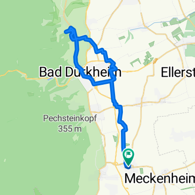
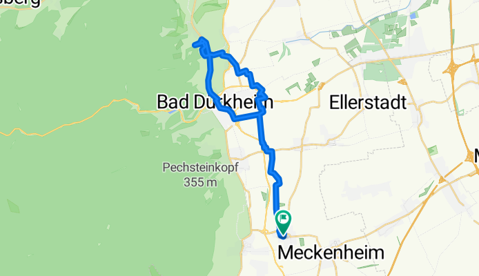
- Niederkrichen - Bad Dürkheim.gpx
- Distance
- 16.6 km
- Ascent
- 55 m
- Descent
- 52 m
- Location
- Niederkirchen bei Deidesheim, Rhineland-Palatinate, Germany
- Michaelskapelle - Heidenlöcher - Am Weißenstich
- Distance
- 28.1 km
- Ascent
- 574 m
- Descent
- 574 m
- Location
- Niederkirchen bei Deidesheim, Rhineland-Palatinate, Germany
- Am Weißentsich - Wachenheim
- Distance
- 29.6 km
- Ascent
- 487 m
- Descent
- 487 m
- Location
- Niederkirchen bei Deidesheim, Rhineland-Palatinate, Germany
- Niederkirchen - Weisenheim am Sand
- Distance
- 44 km
- Ascent
- 113 m
- Descent
- 113 m
- Location
- Niederkirchen bei Deidesheim, Rhineland-Palatinate, Germany
- Niederkirchen - Leistadt
- Distance
- 25.4 km
- Ascent
- 201 m
- Descent
- 198 m
- Location
- Niederkirchen bei Deidesheim, Rhineland-Palatinate, Germany
- Mußbach - Böhl - Hochdorf
- Distance
- 27.6 km
- Ascent
- 38 m
- Descent
- 40 m
- Location
- Niederkirchen bei Deidesheim, Rhineland-Palatinate, Germany
- Haardt - Weinbiet - Haßloch
- Distance
- 41.3 km
- Ascent
- 506 m
- Descent
- 506 m
- Location
- Niederkirchen bei Deidesheim, Rhineland-Palatinate, Germany
Open it in the app