

Bezier
A cycling route starting in Fleury, Occitanie, France.
Overview
About this route
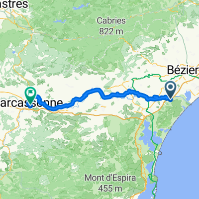
Gravel section on the way from Narbonne to Béziers
- -:--
- Duration
- 17 km
- Distance
- 177 m
- Ascent
- 99 m
- Descent
- ---
- Avg. speed
- ---
- Max. altitude
Route quality
Waytypes & surfaces along the route
Waytypes
Road
11.9 km
(70 %)
Quiet road
0.2 km
(1 %)
Undefined
4.9 km
(29 %)
Surfaces
Paved
10.5 km
(62 %)
Asphalt
10.5 km
(62 %)
Undefined
6.4 km
(38 %)
Continue with Bikemap
Use, edit, or download this cycling route
You would like to ride Bezier or customize it for your own trip? Here is what you can do with this Bikemap route:
Free features
- Save this route as favorite or in collections
- Copy & plan your own version of this route
- Sync your route with Garmin or Wahoo
Premium features
Free trial for 3 days, or one-time payment. More about Bikemap Premium.
- Navigate this route on iOS & Android
- Export a GPX / KML file of this route
- Create your custom printout (try it for free)
- Download this route for offline navigation
Discover more Premium features.
Get Bikemap PremiumFrom our community
Other popular routes starting in Fleury
 122 Les Baraquiers, Fleury à 20 Avenue de Sète, Agde
- Distance
- 48.7 km
- Ascent
- 112 m
- Descent
- 101 m
- Location
- Fleury, Occitanie, France
 From Fleury to Carcassonne 20/08/25
- Distance
- 92.8 km
- Ascent
- 367 m
- Descent
- 258 m
- Location
- Fleury, Occitanie, France
 gruissan
- Distance
- 14.2 km
- Ascent
- 8 m
- Descent
- 5 m
- Location
- Fleury, Occitanie, France
 Vendres par ancien lit et la guarrigue
- Distance
- 14.2 km
- Ascent
- 76 m
- Descent
- 78 m
- Location
- Fleury, Occitanie, France
 test plage
- Distance
- 9.7 km
- Ascent
- 0 m
- Descent
- 15 m
- Location
- Fleury, Occitanie, France
 De Boulevard des Embruns, Fleury à Boulevard des Embruns 5, Fleury
- Distance
- 21.9 km
- Ascent
- 35 m
- Descent
- 34 m
- Location
- Fleury, Occitanie, France
 06 - saint pierre - columbiers
- Distance
- 18.1 km
- Ascent
- 15 m
- Descent
- 14 m
- Location
- Fleury, Occitanie, France
 Bezier
- Distance
- 17 km
- Ascent
- 177 m
- Descent
- 99 m
- Location
- Fleury, Occitanie, France
Open it in the app