

Altenberger Dom
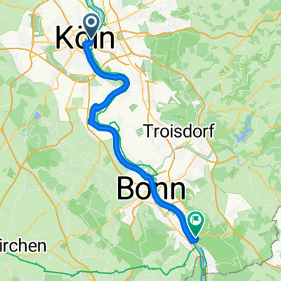
A cycling route starting in Deutz, North Rhine-Westphalia, Germany.
Overview
About this route
The Altenberg Cathedral, often also called the 'Berg Cathedral', is the church of the former Cistercian Abbey of Altenberg (1133-1803) and today the parish church of the Catholic parish of St. Mariä Himmelfahrt, Altenberg.
- -:--
- Duration
- 57.9 km
- Distance
- 138 m
- Ascent
- 143 m
- Descent
- ---
- Avg. speed
- ---
- Max. altitude

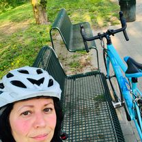
Route photos

Route quality
Waytypes & surfaces along the route
Waytypes
Path
19.1 km
(33 %)
Quiet road
14.5 km
(25 %)
Surfaces
Paved
30.7 km
(53 %)
Unpaved
12.2 km
(21 %)
Asphalt
29.6 km
(51 %)
Gravel
7 km
(12 %)
Route highlights
Points of interest along the route

Point of interest after 22.5 km
Der Altenberger Dom, häufig auch der “Bergische Dom” genannt, ist die Kirche der ehemaligen Zisterzienser-Abtei Altenberg (1133-1803) und heute Pfarrkirche der Kath. Pfarrgemeinde St. Mariä Himmelfahrt, Altenberg.

Point of interest after 22.8 km
Gaststätte Küchenhof Carl-Mosterts-Str. 1 51519 Odenthal - Altenberg Telefon: 021 74 - 41 413

Point of interest after 39 km
China Restaurant die chinesische Mauer Dhünnstr. 2D 51373 Leverkusen Tel. 0214-46768 Samstag, Sonntag 11:30 bis 23:00 Uhr
Continue with Bikemap
Use, edit, or download this cycling route
You would like to ride Altenberger Dom or customize it for your own trip? Here is what you can do with this Bikemap route:
Free features
- Save this route as favorite or in collections
- Copy & plan your own version of this route
- Sync your route with Garmin or Wahoo
Premium features
Free trial for 3 days, or one-time payment. More about Bikemap Premium.
- Navigate this route on iOS & Android
- Export a GPX / KML file of this route
- Create your custom printout (try it for free)
- Download this route for offline navigation
Discover more Premium features.
Get Bikemap PremiumFrom our community
Other popular routes starting in Deutz
 HM 2023.08.14.kml_HM 2023
- Distance
- 21.2 km
- Ascent
- 0 m
- Descent
- 0 m
- Location
- Deutz, North Rhine-Westphalia, Germany
 Von Köln Messe Deutz bis Wuppertal
- Distance
- 117.9 km
- Ascent
- 1,624 m
- Descent
- 1,440 m
- Location
- Deutz, North Rhine-Westphalia, Germany
 Von Köln bis Königswinter
- Distance
- 48.5 km
- Ascent
- 213 m
- Descent
- 192 m
- Location
- Deutz, North Rhine-Westphalia, Germany
 Eschmarer Mühle_Siegfähre
- Distance
- 61.7 km
- Ascent
- 93 m
- Descent
- 93 m
- Location
- Deutz, North Rhine-Westphalia, Germany
 Wahnheide
- Distance
- 59.3 km
- Ascent
- 170 m
- Descent
- 159 m
- Location
- Deutz, North Rhine-Westphalia, Germany
 deutz-benrath
- Distance
- 40.8 km
- Ascent
- 1,573 m
- Descent
- 1,577 m
- Location
- Deutz, North Rhine-Westphalia, Germany
 Apple Watch - 08.04.20, 15:39
- Distance
- 20.8 km
- Ascent
- 42 m
- Descent
- 42 m
- Location
- Deutz, North Rhine-Westphalia, Germany
 Bieselwald Grengel
- Distance
- 34.6 km
- Ascent
- 50 m
- Descent
- 64 m
- Location
- Deutz, North Rhine-Westphalia, Germany
Open it in the app