

vom Kottenforst zum Königsforst
A cycling route starting in Meckenheim, North Rhine-Westphalia, Germany.
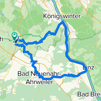
Overview
About this route
Those who explore the forest today by bike, on foot, or on inline skates are moving along historic paths. The unique avenue system dates back to the time of the Elector of Cologne, Clemens August, who used the Kottenforst for parforce hunting. This unique avenue system has also been transferred to Königsforst.
- -:--
- Duration
- 64.6 km
- Distance
- 173 m
- Ascent
- 286 m
- Descent
- ---
- Avg. speed
- ---
- Max. altitude

Route quality
Waytypes & surfaces along the route
Waytypes
Path
26.5 km
(41 %)
Track
16.8 km
(26 %)
Surfaces
Paved
47.1 km
(73 %)
Unpaved
10.3 km
(16 %)
Asphalt
45.2 km
(70 %)
Gravel
8.4 km
(13 %)
Route highlights
Points of interest along the route
Accommodation after 36.6 km
Maigermühle Erlebnisbrauerei Lohmar Meigermühle 1 53797 Lohmar Tel: 02246 - 5000 Sonntag von 11:00 bis 22:00
Continue with Bikemap
Use, edit, or download this cycling route
You would like to ride vom Kottenforst zum Königsforst or customize it for your own trip? Here is what you can do with this Bikemap route:
Free features
- Save this route as favorite or in collections
- Copy & plan your own version of this route
- Sync your route with Garmin or Wahoo
Premium features
Free trial for 3 days, or one-time payment. More about Bikemap Premium.
- Navigate this route on iOS & Android
- Export a GPX / KML file of this route
- Create your custom printout (try it for free)
- Download this route for offline navigation
Discover more Premium features.
Get Bikemap PremiumFrom our community
Other popular routes starting in Meckenheim
 Meckenheim - Rech
- Distance
- 44.7 km
- Ascent
- 760 m
- Descent
- 760 m
- Location
- Meckenheim, North Rhine-Westphalia, Germany
 Kottenforst-Ville
- Distance
- 62.3 km
- Ascent
- 106 m
- Descent
- 227 m
- Location
- Meckenheim, North Rhine-Westphalia, Germany
 Rund um Rheinbach, Ahr und Eifel
- Distance
- 62.6 km
- Ascent
- 440 m
- Descent
- 440 m
- Location
- Meckenheim, North Rhine-Westphalia, Germany
 Kottenforst-Runde
- Distance
- 18.5 km
- Ascent
- 104 m
- Descent
- 104 m
- Location
- Meckenheim, North Rhine-Westphalia, Germany
 vom Kottenforst zum Königsforst
- Distance
- 64.6 km
- Ascent
- 173 m
- Descent
- 286 m
- Location
- Meckenheim, North Rhine-Westphalia, Germany
 Small round south of Bonn, Germany
- Distance
- 58.4 km
- Ascent
- 300 m
- Descent
- 290 m
- Location
- Meckenheim, North Rhine-Westphalia, Germany
 Am Rebstock 11, Meckenheim nach Am Rebstock 22, Meckenheim
- Distance
- 14.2 km
- Ascent
- 86 m
- Descent
- 95 m
- Location
- Meckenheim, North Rhine-Westphalia, Germany
 Tomburg
- Distance
- 9.7 km
- Ascent
- 119 m
- Descent
- 21 m
- Location
- Meckenheim, North Rhine-Westphalia, Germany
Open it in the app