
Kalltall - Route
A cycling route starting in Monschau, North Rhine-Westphalia, Germany.
Overview
About this route
Die Kall ist ein zwar wenig beachteter, aber dabei umso schönerer Nebenfluß der Rur. Dieser kleine Fluß entspringt im deutsch-belgischen Grenzgebiet nahe der Ortschaft Konzen
- -:--
- Duration
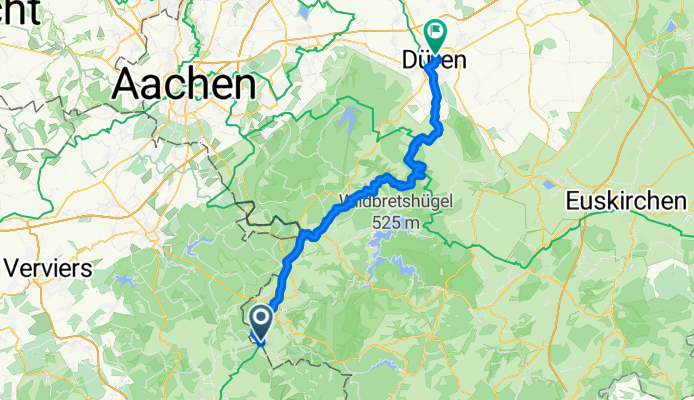
- 57.8 km
- Distance
- 84 m
- Ascent
- 467 m
- Descent
- ---
- Avg. speed
- ---
- Avg. speed

Route highlights
Points of interest along the route

Photo after 18.5 km
Kalltalsperre

Point of interest after 24.2 km
Café Kern - Simonskall Simonskall 25, 52393 Hürtgenwald Telefon:02429 2485 Samstag, Sonntag: 9.00 Uhr - 19.00 Uh

Accommodation after 27.3 km
Restaurant Mestrenger Mühle Mestrenger Mühle 0, 52393 Vossenack, Deutschland Tel: 0 24 74 - 998 70 85 Samstag und Sonntag 11:00 - 19:00 Uhr

Point of interest after 42.7 km
Strep - Am Stausee Kreuzau - Obermaubach Tel. 024 22 / 74 54 Samstag bis Sonntag ab 10:00 Uhr geöffnet
Continue with Bikemap
Use, edit, or download this cycling route
You would like to ride Kalltall - Route or customize it for your own trip? Here is what you can do with this Bikemap route:
Free features
- Save this route as favorite or in collections
- Copy & plan your own version of this route
- Sync your route with Garmin or Wahoo
Premium features
Free trial for 3 days, or one-time payment. More about Bikemap Premium.
- Navigate this route on iOS & Android
- Export a GPX / KML file of this route
- Create your custom printout (try it for free)
- Download this route for offline navigation
Discover more Premium features.
Get Bikemap PremiumFrom our community
Other popular routes starting in Monschau
 VB Monschau to Roetgen
- Distance
- 20.9 km
- Ascent
- 164 m
- Descent
- 147 m
- Location
- Monschau, North Rhine-Westphalia, Germany
 Rurseerunde
- Distance
- 43.8 km
- Ascent
- 697 m
- Descent
- 695 m
- Location
- Monschau, North Rhine-Westphalia, Germany
 Dreier Singletrail - bist platt danach
- Distance
- 6.1 km
- Ascent
- 283 m
- Descent
- 270 m
- Location
- Monschau, North Rhine-Westphalia, Germany
 Volg de Rur
- Distance
- 18.1 km
- Ascent
- 271 m
- Descent
- 271 m
- Location
- Monschau, North Rhine-Westphalia, Germany
 Van Imgenbroich naar Burg-Reuland
- Distance
- 63.2 km
- Ascent
- 579 m
- Descent
- 742 m
- Location
- Monschau, North Rhine-Westphalia, Germany
 Monschau Venn
- Distance
- 57.6 km
- Ascent
- 649 m
- Descent
- 666 m
- Location
- Monschau, North Rhine-Westphalia, Germany
 Rondje stuwmeer 100km
- Distance
- 101.6 km
- Ascent
- 1,262 m
- Descent
- 1,262 m
- Location
- Monschau, North Rhine-Westphalia, Germany
 Vennbahn - Day 3 - Loop 3 - Das Hohe Venn im Hertogenwald
- Distance
- 34.7 km
- Ascent
- 430 m
- Descent
- 430 m
- Location
- Monschau, North Rhine-Westphalia, Germany
Open it in the app