

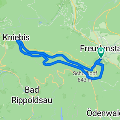
Freudenstadt für die Mittagspause
A cycling route starting in Freudenstadt, Baden-Wurttemberg, Germany.
Overview
About this route
Obwohl man etwa 250 m Steigung auf 9 Kilometern bewältigen muss (Gesamtlänge 18 Km), ist nur eine nennenswerte Steigung mit 800 Meter Länge dabei. Gerade richtig, um abends noch rasch loszufahren oder in der Mittagspause was für sich zu tun. Dort, wo keine Wege in der Karte eingezeichnet sind, einfach immer geradeaus fahren, im Zweifel an eine Weggabelung den nach oben führenden Weg nehmen. Ein mittelmäßiger Radler schafft die Strecke in ca. 50 Minuten. Bis zum Kniebis kann man sich ruhig verausgaben, weil der Rückweg auf asphaltierter Strecke (ohne Verkehr) leicht zu bewältigen ist.
- -:--
- Duration
- 19.7 km
- Distance
- 294 m
- Ascent
- 294 m
- Descent
- ---
- Avg. speed
- ---
- Max. altitude
Continue with Bikemap
Use, edit, or download this cycling route
You would like to ride Freudenstadt für die Mittagspause or customize it for your own trip? Here is what you can do with this Bikemap route:
Free features
- Save this route as favorite or in collections
- Copy & plan your own version of this route
- Sync your route with Garmin or Wahoo
Premium features
Free trial for 3 days, or one-time payment. More about Bikemap Premium.
- Navigate this route on iOS & Android
- Export a GPX / KML file of this route
- Create your custom printout (try it for free)
- Download this route for offline navigation
Discover more Premium features.
Get Bikemap PremiumFrom our community
Other popular routes starting in Freudenstadt
 Schwarzwald Panorama-Radweg Tag 2
- Distance
- 59.1 km
- Ascent
- 528 m
- Descent
- 495 m
- Location
- Freudenstadt, Baden-Wurttemberg, Germany
 Freudenstadt für die Mittagspause
- Distance
- 19.7 km
- Ascent
- 294 m
- Descent
- 294 m
- Location
- Freudenstadt, Baden-Wurttemberg, Germany
 Tour Schwarzwald - Kleines Kinzigtal
- Distance
- 41.6 km
- Ascent
- 674 m
- Descent
- 677 m
- Location
- Freudenstadt, Baden-Wurttemberg, Germany
 Ausfahrt durch Freudenstadt
- Distance
- 27.9 km
- Ascent
- 397 m
- Descent
- 398 m
- Location
- Freudenstadt, Baden-Wurttemberg, Germany
 Über den Kniebis zum Sankenbach
- Distance
- 35.4 km
- Ascent
- 516 m
- Descent
- 586 m
- Location
- Freudenstadt, Baden-Wurttemberg, Germany
 Von Freudenstadt bis Elzach
- Distance
- 73.1 km
- Ascent
- 1,891 m
- Descent
- 2,225 m
- Location
- Freudenstadt, Baden-Wurttemberg, Germany
 Sankenbachsee
- Distance
- 19.6 km
- Ascent
- 433 m
- Descent
- 431 m
- Location
- Freudenstadt, Baden-Wurttemberg, Germany
 Kniebis- Baiersbronn runde
- Distance
- 31.6 km
- Ascent
- 549 m
- Descent
- 545 m
- Location
- Freudenstadt, Baden-Wurttemberg, Germany
Open it in the app