
corniche_du_Drac_seul
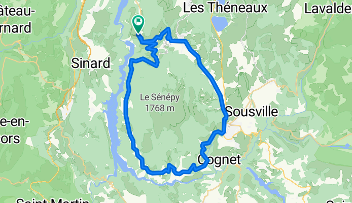
A cycling route starting in La Motte-Saint-Martin, Auvergne-Rhône-Alpes, France.
Overview
About this route
df
- -:--
- Duration
- 41.3 km
- Distance
- 565 m
- Ascent
- 566 m
- Descent
- ---
- Avg. speed
- ---
- Max. altitude

Route quality
Waytypes & surfaces along the route
Waytypes
Quiet road
1.2 km
(3 %)
Undefined
40 km
(97 %)
Surfaces
Paved
22.3 km
(54 %)
Asphalt
22.3 km
(54 %)
Undefined
19 km
(46 %)
Continue with Bikemap
Use, edit, or download this cycling route
You would like to ride corniche_du_Drac_seul or customize it for your own trip? Here is what you can do with this Bikemap route:
Free features
- Save this route as favorite or in collections
- Copy & plan your own version of this route
- Sync your route with Garmin or Wahoo
Premium features
Free trial for 3 days, or one-time payment. More about Bikemap Premium.
- Navigate this route on iOS & Android
- Export a GPX / KML file of this route
- Create your custom printout (try it for free)
- Download this route for offline navigation
Discover more Premium features.
Get Bikemap PremiumFrom our community
Other popular routes starting in La Motte-Saint-Martin
 200521_retour_Allimas_Uriage
- Distance
- 53.7 km
- Ascent
- 188 m
- Descent
- 1,117 m
- Location
- La Motte-Saint-Martin, Auvergne-Rhône-Alpes, France
 22-13
22-13- Distance
- 55.3 km
- Ascent
- 810 m
- Descent
- 1,063 m
- Location
- La Motte-Saint-Martin, Auvergne-Rhône-Alpes, France
 maison_parentlukas
- Distance
- 90 km
- Ascent
- 1,353 m
- Descent
- 1,870 m
- Location
- La Motte-Saint-Martin, Auvergne-Rhône-Alpes, France
 Tornicoti
- Distance
- 34.6 km
- Ascent
- 680 m
- Descent
- 673 m
- Location
- La Motte-Saint-Martin, Auvergne-Rhône-Alpes, France
 gre-villard
- Distance
- 58.1 km
- Ascent
- 881 m
- Descent
- 1,385 m
- Location
- La Motte-Saint-Martin, Auvergne-Rhône-Alpes, France
 171–503 Chemin de Pabra, Treffort naar Treffort
- Distance
- 1.2 km
- Ascent
- 17 m
- Descent
- 14 m
- Location
- La Motte-Saint-Martin, Auvergne-Rhône-Alpes, France
 Lac de Monteynard/Monestier/Mens/Clelles
- Distance
- 45.3 km
- Ascent
- 1,093 m
- Descent
- 756 m
- Location
- La Motte-Saint-Martin, Auvergne-Rhône-Alpes, France
 Allauch 2002 25.5. Tag08
- Distance
- 110.5 km
- Ascent
- 530 m
- Descent
- 884 m
- Location
- La Motte-Saint-Martin, Auvergne-Rhône-Alpes, France
Open it in the app