
2. Etappe Garmisch- Venedig
A cycling route starting in Graun im Vinschgau, Trentino-Alto Adige, Italy.
Overview
About this route
-
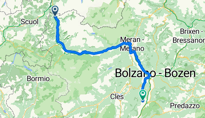
Etappe Reschen - Tramin
Von Reschen über Glurns, Mals, Schlanders, Meran und Bozen nach Tramin durchs gesamte Vinschgau
- -:--
- Duration
- 126.3 km
- Distance
- 389 m
- Ascent
- 1,656 m
- Descent
- ---
- Avg. speed
- ---
- Avg. speed

Route quality
Waytypes & surfaces along the route
Waytypes
Busy road
81.6 km
(65 %)
Quiet road
15.7 km
(12 %)
Surfaces
Paved
112 km
(89 %)
Unpaved
4.9 km
(4 %)
Asphalt
111.4 km
(88 %)
Ground
2.4 km
(2 %)
Continue with Bikemap
Use, edit, or download this cycling route
You would like to ride 2. Etappe Garmisch- Venedig or customize it for your own trip? Here is what you can do with this Bikemap route:
Free features
- Save this route as favorite or in collections
- Copy & plan your own version of this route
- Split it into stages to create a multi-day tour
- Sync your route with Garmin or Wahoo
Premium features
Free trial for 3 days, or one-time payment. More about Bikemap Premium.
- Navigate this route on iOS & Android
- Export a GPX / KML file of this route
- Create your custom printout (try it for free)
- Download this route for offline navigation
Discover more Premium features.
Get Bikemap PremiumFrom our community
Other popular routes starting in Graun im Vinschgau
 vom Reschen nach Bozen
- Distance
- 120.7 km
- Ascent
- 172 m
- Descent
- 1,416 m
- Location
- Graun im Vinschgau, Trentino-Alto Adige, Italy
 Reg.Reschensee-Obervinschgau - Meran
- Distance
- 73.5 km
- Ascent
- 467 m
- Descent
- 1,626 m
- Location
- Graun im Vinschgau, Trentino-Alto Adige, Italy
 Lago di Resia - Chiavenna
- Distance
- 151.3 km
- Ascent
- 1,161 m
- Descent
- 2,424 m
- Location
- Graun im Vinschgau, Trentino-Alto Adige, Italy
 Od Haidersee přes Nauders do Pfunds
- Distance
- 41.1 km
- Ascent
- 259 m
- Descent
- 735 m
- Location
- Graun im Vinschgau, Trentino-Alto Adige, Italy
 02 Schöneben - Prad
- Distance
- 36.2 km
- Ascent
- 446 m
- Descent
- 1,649 m
- Location
- Graun im Vinschgau, Trentino-Alto Adige, Italy
 der Ritterschlag das Stilfserjoch
- Distance
- 94.5 km
- Ascent
- 2,445 m
- Descent
- 2,429 m
- Location
- Graun im Vinschgau, Trentino-Alto Adige, Italy
 From Curon Venosta to Nauders
- Distance
- 5.1 km
- Ascent
- 566 m
- Descent
- 65 m
- Location
- Graun im Vinschgau, Trentino-Alto Adige, Italy
 Day 4: Reschensee to Merano
- Distance
- 78.1 km
- Ascent
- 518 m
- Descent
- 1,739 m
- Location
- Graun im Vinschgau, Trentino-Alto Adige, Italy
Open it in the app