

d-vértes01
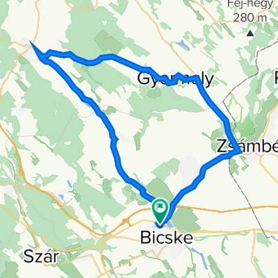
A cycling route starting in Bicske, Fejér, Hungary.
Overview
About this route
nincsenek komoly emelkedők, inkább alattomosak
Felcsút ; Újbarok ; Szár Rákóczi Ferenc utca, József Attila utca ;Vérteskozma ; Csákberény ; Csákvár ; Vértesboglár ; Bodmér ; Felcsút (Csákvár-Felcsút haladós, forgalmas) - -:--
- Duration
- 79.8 km
- Distance
- 570 m
- Ascent
- 572 m
- Descent
- ---
- Avg. speed
- ---
- Max. altitude
Route quality
Waytypes & surfaces along the route
Waytypes
Quiet road
33.5 km
(42 %)
Track
8 km
(10 %)
Surfaces
Paved
55.9 km
(70 %)
Unpaved
6.4 km
(8 %)
Asphalt
55.9 km
(70 %)
Unpaved (undefined)
3.2 km
(4 %)
Continue with Bikemap
Use, edit, or download this cycling route
You would like to ride d-vértes01 or customize it for your own trip? Here is what you can do with this Bikemap route:
Free features
- Save this route as favorite or in collections
- Copy & plan your own version of this route
- Sync your route with Garmin or Wahoo
Premium features
Free trial for 3 days, or one-time payment. More about Bikemap Premium.
- Navigate this route on iOS & Android
- Export a GPX / KML file of this route
- Create your custom printout (try it for free)
- Download this route for offline navigation
Discover more Premium features.
Get Bikemap PremiumFrom our community
Other popular routes starting in Bicske
 Királyi-kör
- Distance
- 92.1 km
- Ascent
- 459 m
- Descent
- 459 m
- Location
- Bicske, Fejér, Hungary
 Etyekwood Hills forever
- Distance
- 53.1 km
- Ascent
- 268 m
- Descent
- 295 m
- Location
- Bicske, Fejér, Hungary
 Alcsúti arborétum
- Distance
- 4.8 km
- Ascent
- 38 m
- Descent
- 38 m
- Location
- Bicske, Fejér, Hungary
 Bicske-Alcsút-Pázmánd-Velence, könnyített
- Distance
- 71.2 km
- Ascent
- 285 m
- Descent
- 350 m
- Location
- Bicske, Fejér, Hungary
 Bicske-Csákvár bejárótúrás
- Distance
- 101.7 km
- Ascent
- 998 m
- Descent
- 1,011 m
- Location
- Bicske, Fejér, Hungary
 Route in Felcsút
- Distance
- 101.8 km
- Ascent
- 565 m
- Descent
- 587 m
- Location
- Bicske, Fejér, Hungary
 Kossuth utca 64, Bicske to Kossuth utca 64, Bicske
- Distance
- 43.7 km
- Ascent
- 112 m
- Descent
- 341 m
- Location
- Bicske, Fejér, Hungary
 Herceghalom Tata
- Distance
- 55 km
- Ascent
- 2,346 m
- Descent
- 2,367 m
- Location
- Bicske, Fejér, Hungary
Open it in the app