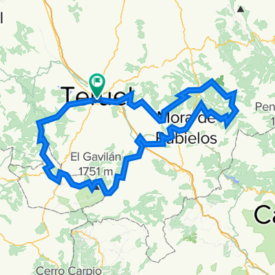
Teruel-Sagunto
A cycling route starting in Teruel, Aragon, Spain.
Overview
About this route
Via Verde
- -:--
- Duration
- 149.5 km
- Distance
- 379 m
- Ascent
- 1,257 m
- Descent
- ---
- Avg. speed
- ---
- Max. altitude
Route quality
Waytypes & surfaces along the route
Waytypes
Track
97.1 km
(65 %)
Quiet road
23.9 km
(16 %)
Surfaces
Paved
98.6 km
(66 %)
Unpaved
13.5 km
(9 %)
Paved (undefined)
94.2 km
(63 %)
Unpaved (undefined)
6 km
(4 %)
Continue with Bikemap
Use, edit, or download this cycling route
You would like to ride Teruel-Sagunto or customize it for your own trip? Here is what you can do with this Bikemap route:
Free features
- Save this route as favorite or in collections
- Copy & plan your own version of this route
- Split it into stages to create a multi-day tour
- Sync your route with Garmin or Wahoo
Premium features
Free trial for 3 days, or one-time payment. More about Bikemap Premium.
- Navigate this route on iOS & Android
- Export a GPX / KML file of this route
- Create your custom printout (try it for free)
- Download this route for offline navigation
Discover more Premium features.
Get Bikemap PremiumFrom our community
Other popular routes starting in Teruel
- VIA VERDE Sagunto - teruel
- Distance
- 147.3 km
- Ascent
- 319 m
- Descent
- 1,276 m
- Location
- Teruel, Aragon, Spain
- Teruel - Mora de Rubielos
- Distance
- 48.5 km
- Ascent
- 508 m
- Descent
- 402 m
- Location
- Teruel, Aragon, Spain
- 1 Teruel-Albarracín-Guadalaviar
- Distance
- 79.6 km
- Ascent
- 1,327 m
- Descent
- 667 m
- Location
- Teruel, Aragon, Spain
- 20100530-Via Verde
- Distance
- 132.7 km
- Ascent
- 358 m
- Descent
- 1,150 m
- Location
- Teruel, Aragon, Spain
- MONTAÑAS VACÍAS - SIERRA DE ALBARRACÍN
- Distance
- 127.6 km
- Ascent
- 2,956 m
- Descent
- 2,301 m
- Location
- Teruel, Aragon, Spain
- Teruel-MoraRubielos-Valdelinares-Teruel
- Distance
- 132.1 km
- Ascent
- 1,736 m
- Descent
- 1,726 m
- Location
- Teruel, Aragon, Spain
- MINA DE OJOS NEGROS, TRAMO TERUEL-BARRACAS-JERICA
- Distance
- 98 km
- Ascent
- 774 m
- Descent
- 1,027 m
- Location
- Teruel, Aragon, Spain
- Teruel-Sagunto
- Distance
- 149.5 km
- Ascent
- 379 m
- Descent
- 1,257 m
- Location
- Teruel, Aragon, Spain
Open it in the app