Münsterland - Teutoburger Wald Tag 2
A cycling route starting in Bad Iburg, Lower Saxony, Germany.
Overview
About this route
C2 Münsterland - Teutoburger Wald
- -:--
- Duration
- 61.1 km
- Distance
- 116 m
- Ascent
- 236 m
- Descent
- ---
- Avg. speed
- ---
- Max. altitude
Route quality
Waytypes & surfaces along the route
Waytypes
Quiet road
26.3 km
(43 %)
Cycleway
9.8 km
(16 %)
Surfaces
Paved
34.8 km
(57 %)
Unpaved
5.5 km
(9 %)
Asphalt
34.8 km
(57 %)
Gravel
3.1 km
(5 %)
Continue with Bikemap
Use, edit, or download this cycling route
You would like to ride Münsterland - Teutoburger Wald Tag 2 or customize it for your own trip? Here is what you can do with this Bikemap route:
Free features
- Save this route as favorite or in collections
- Copy & plan your own version of this route
- Sync your route with Garmin or Wahoo
Premium features
Free trial for 3 days, or one-time payment. More about Bikemap Premium.
- Navigate this route on iOS & Android
- Export a GPX / KML file of this route
- Create your custom printout (try it for free)
- Download this route for offline navigation
Discover more Premium features.
Get Bikemap PremiumFrom our community
Other popular routes starting in Bad Iburg
- MTB 17.09.2020
- Distance
- 15.9 km
- Ascent
- 413 m
- Descent
- 413 m
- Location
- Bad Iburg, Lower Saxony, Germany
- Teutotour
- Distance
- 40.8 km
- Ascent
- 590 m
- Descent
- 544 m
- Location
- Bad Iburg, Lower Saxony, Germany
- Mountainbike Touren ± 2,5 uur
- Distance
- 21 km
- Ascent
- 415 m
- Descent
- 417 m
- Location
- Bad Iburg, Lower Saxony, Germany
- Glane-Lengering-Lienen-Glane
- Distance
- 45.3 km
- Ascent
- 69 m
- Descent
- 70 m
- Location
- Bad Iburg, Lower Saxony, Germany
- Sonntagsrunde 26.07.2020 in Bad Iburg
- Distance
- 18.1 km
- Ascent
- 369 m
- Descent
- 367 m
- Location
- Bad Iburg, Lower Saxony, Germany
- Bad Iburg lang un schmutzig
- Distance
- 30.4 km
- Ascent
- 698 m
- Descent
- 698 m
- Location
- Bad Iburg, Lower Saxony, Germany
- FR04_Bad-Iburg-Telgte
- Distance
- 47.3 km
- Ascent
- 148 m
- Descent
- 228 m
- Location
- Bad Iburg, Lower Saxony, Germany
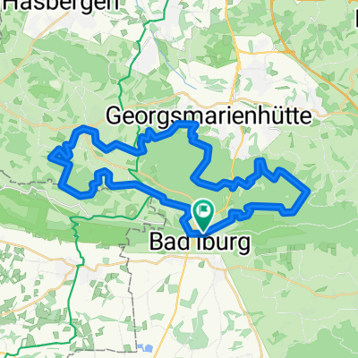
- Ahornweg kurz CLONED FROM ROUTE 147535
- Distance
- 38.5 km
- Ascent
- 729 m
- Descent
- 727 m
- Location
- Bad Iburg, Lower Saxony, Germany
Open it in the app