

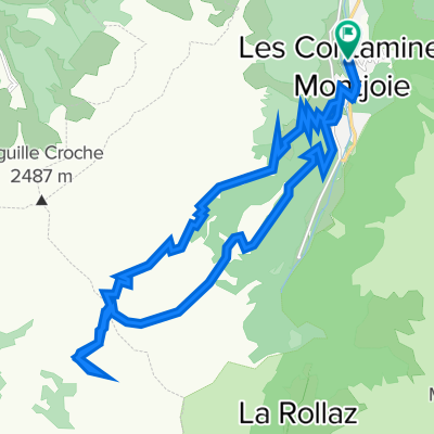
Col du Joly and l'Aguille Croche
A cycling route starting in Les Contamines-Montjoie, Auvergne-Rhône-Alpes, France.
Overview
About this route
Superb mountain bike climb up through Les Contamines ski station to Col du Joly then much higher (2435m) to l'Aguille Croche
- -:--
- Duration
- 30.3 km
- Distance
- 1,309 m
- Ascent
- 1,309 m
- Descent
- ---
- Avg. speed
- ---
- Max. altitude

Route highlights
Points of interest along the route
Point of interest after 12 km
Col du Joly
Point of interest after 16.3 km
Aguille Croche
Continue with Bikemap
Use, edit, or download this cycling route
You would like to ride Col du Joly and l'Aguille Croche or customize it for your own trip? Here is what you can do with this Bikemap route:
Free features
- Save this route as favorite or in collections
- Copy & plan your own version of this route
- Sync your route with Garmin or Wahoo
Premium features
Free trial for 3 days, or one-time payment. More about Bikemap Premium.
- Navigate this route on iOS & Android
- Export a GPX / KML file of this route
- Create your custom printout (try it for free)
- Download this route for offline navigation
Discover more Premium features.
Get Bikemap PremiumFrom our community
Other popular routes starting in Les Contamines-Montjoie
 OLD_Day6GiteLePontetToChamonixTMB
- Distance
- 16.2 km
- Ascent
- 1,370 m
- Descent
- 781 m
- Location
- Les Contamines-Montjoie, Auvergne-Rhône-Alpes, France
 MontBlancTour3Tag
- Distance
- 32.9 km
- Ascent
- 1,710 m
- Descent
- 1,581 m
- Location
- Les Contamines-Montjoie, Auvergne-Rhône-Alpes, France
 Aguille Croche via Col du Joly
- Distance
- 28.6 km
- Ascent
- 1,299 m
- Descent
- 1,300 m
- Location
- Les Contamines-Montjoie, Auvergne-Rhône-Alpes, France
 Col du Joly
- Distance
- 21.9 km
- Ascent
- 1,090 m
- Descent
- 1,095 m
- Location
- Les Contamines-Montjoie, Auvergne-Rhône-Alpes, France
 tmb dag 3
- Distance
- 38.9 km
- Ascent
- 2,546 m
- Descent
- 2,127 m
- Location
- Les Contamines-Montjoie, Auvergne-Rhône-Alpes, France
 MontBlancTour4Tag
- Distance
- 52.1 km
- Ascent
- 1,914 m
- Descent
- 2,578 m
- Location
- Les Contamines-Montjoie, Auvergne-Rhône-Alpes, France
 Day6GiteLePontetToChamonixTMB
- Distance
- 25.9 km
- Ascent
- 1,503 m
- Descent
- 2,690 m
- Location
- Les Contamines-Montjoie, Auvergne-Rhône-Alpes, France
 TMB 6
TMB 6- Distance
- 15.8 km
- Ascent
- 957 m
- Descent
- 1,087 m
- Location
- Les Contamines-Montjoie, Auvergne-Rhône-Alpes, France
Open it in the app