
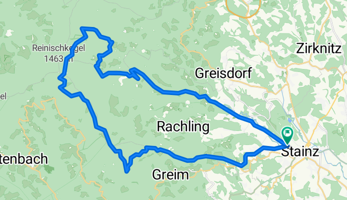
Reinischkogel
A cycling route starting in Stainz, Styria, Austria.
Overview
About this route
Reinischkogel
- -:--
- Duration
- 34.5 km
- Distance
- 1,170 m
- Ascent
- 1,171 m
- Descent
- ---
- Avg. speed
- ---
- Max. altitude
Continue with Bikemap
Use, edit, or download this cycling route
You would like to ride Reinischkogel or customize it for your own trip? Here is what you can do with this Bikemap route:
Free features
- Save this route as favorite or in collections
- Copy & plan your own version of this route
- Sync your route with Garmin or Wahoo
Premium features
Free trial for 3 days, or one-time payment. More about Bikemap Premium.
- Navigate this route on iOS & Android
- Export a GPX / KML file of this route
- Create your custom printout (try it for free)
- Download this route for offline navigation
Discover more Premium features.
Get Bikemap PremiumFrom our community
Other popular routes starting in Stainz
 Stainz nach Hauptplatz, Graz
- Distance
- 43.4 km
- Ascent
- 1,135 m
- Descent
- 778 m
- Location
- Stainz, Styria, Austria
 Samahof - Gerhard´s Runde
- Distance
- 49.7 km
- Ascent
- 523 m
- Descent
- 523 m
- Location
- Stainz, Styria, Austria
 Kollmanngasse 18a nach Kollmanngasse 18a
- Distance
- 20.3 km
- Ascent
- 250 m
- Descent
- 250 m
- Location
- Stainz, Styria, Austria
 Ausfahrt 18.06.2011
- Distance
- 71.3 km
- Ascent
- 349 m
- Descent
- 349 m
- Location
- Stainz, Styria, Austria
 Stainz-Rassach-Gersdorf-Gamsgebirg-Sierling-Stainz
- Distance
- 22.8 km
- Ascent
- 592 m
- Descent
- 592 m
- Location
- Stainz, Styria, Austria
 Schilcher Tour Nord
- Distance
- 43.8 km
- Ascent
- 1,018 m
- Descent
- 1,020 m
- Location
- Stainz, Styria, Austria
 Wald ob Stainz Rath nach Wald ob Stainz Rath
- Distance
- 39.5 km
- Ascent
- 1,005 m
- Descent
- 1,003 m
- Location
- Stainz, Styria, Austria
 Schilcher Tour Nord Variante 1 - Schilcher Tour Nord Variante 1
- Distance
- 27.5 km
- Ascent
- 650 m
- Descent
- 652 m
- Location
- Stainz, Styria, Austria
Open it in the app