

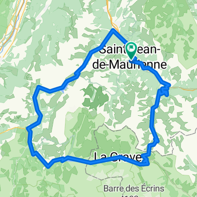
la montée à LA TOUSSUIRE
A cycling route starting in Saint-Jean-de-Maurienne, Auvergne-Rhône-Alpes, France.
Overview
About this route
The climb to LA TOUSSUIRE 1720M From ST JEAN DE M. Fairly difficult... Sportive Ascent via FONTCOUVERTE LE CORBIER exclusive...
- -:--
- Duration
- 33.9 km
- Distance
- 1,172 m
- Ascent
- 1,173 m
- Descent
- ---
- Avg. speed
- ---
- Max. altitude
Route quality
Waytypes & surfaces along the route
Waytypes
Road
4.1 km
(12 %)
Undefined
29.8 km
(88 %)
Surfaces
Paved
32.9 km
(97 %)
Asphalt
32.9 km
(97 %)
Undefined
1 km
(3 %)
Route highlights
Points of interest along the route

Point of interest after 6.3 km
la bise

Point of interest after 9 km
FONTCOUVERTE

Point of interest after 10.5 km
vue des aiguilles

Point of interest after 15.4 km
arrivee a la toussuire

Point of interest after 16.9 km
1720m
Continue with Bikemap
Use, edit, or download this cycling route
You would like to ride la montée à LA TOUSSUIRE or customize it for your own trip? Here is what you can do with this Bikemap route:
Free features
- Save this route as favorite or in collections
- Copy & plan your own version of this route
- Sync your route with Garmin or Wahoo
Premium features
Free trial for 3 days, or one-time payment. More about Bikemap Premium.
- Navigate this route on iOS & Android
- Export a GPX / KML file of this route
- Create your custom printout (try it for free)
- Download this route for offline navigation
Discover more Premium features.
Get Bikemap PremiumFrom our community
Other popular routes starting in Saint-Jean-de-Maurienne
 chaussy
- Distance
- 67.8 km
- Ascent
- 2,279 m
- Descent
- 2,290 m
- Location
- Saint-Jean-de-Maurienne, Auvergne-Rhône-Alpes, France
 Maurienne - J3 Bis
- Distance
- 165.7 km
- Ascent
- 3,339 m
- Descent
- 3,340 m
- Location
- Saint-Jean-de-Maurienne, Auvergne-Rhône-Alpes, France
 Maurienne - J4
- Distance
- 76.9 km
- Ascent
- 2,005 m
- Descent
- 2,005 m
- Location
- Saint-Jean-de-Maurienne, Auvergne-Rhône-Alpes, France
 020 - 2014
- Distance
- 71.8 km
- Ascent
- 1,404 m
- Descent
- 178 m
- Location
- Saint-Jean-de-Maurienne, Auvergne-Rhône-Alpes, France
 la montée à LA TOUSSUIRE
- Distance
- 33.9 km
- Ascent
- 1,172 m
- Descent
- 1,173 m
- Location
- Saint-Jean-de-Maurienne, Auvergne-Rhône-Alpes, France
 montée oullaz par jarrier 002
- Distance
- 12.8 km
- Ascent
- 1,016 m
- Descent
- 30 m
- Location
- Saint-Jean-de-Maurienne, Auvergne-Rhône-Alpes, France
 Maurienne - J3
- Distance
- 164.2 km
- Ascent
- 3,430 m
- Descent
- 3,429 m
- Location
- Saint-Jean-de-Maurienne, Auvergne-Rhône-Alpes, France
 Rohne-Alpes: Etappe 3
- Distance
- 69.5 km
- Ascent
- 2,031 m
- Descent
- 1,732 m
- Location
- Saint-Jean-de-Maurienne, Auvergne-Rhône-Alpes, France
Open it in the app