

Ruta de ciclismo INJUVE
A cycling route starting in Jerez de García Salinas, Zacatecas, Mexico.
Overview
About this route
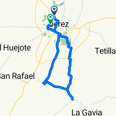
The ride will start at 4:30pm at the Oxxo roundabout, we will go to Jomulquillo then to San Juan del Centro and return along one side of the road leading to Fresnillo, ending the ride where it started.
- -:--
- Duration
- 19.1 km
- Distance
- 88 m
- Ascent
- 85 m
- Descent
- ---
- Avg. speed
- ---
- Max. altitude
Route quality
Waytypes & surfaces along the route
Waytypes
Quiet road
11.9 km
(62 %)
Road
4.2 km
(22 %)
Surfaces
Paved
3.1 km
(16 %)
Asphalt
2.9 km
(15 %)
Concrete
0.2 km
(1 %)
Undefined
16.1 km
(84 %)
Continue with Bikemap
Use, edit, or download this cycling route
You would like to ride Ruta de ciclismo INJUVE or customize it for your own trip? Here is what you can do with this Bikemap route:
Free features
- Save this route as favorite or in collections
- Copy & plan your own version of this route
- Sync your route with Garmin or Wahoo
Premium features
Free trial for 3 days, or one-time payment. More about Bikemap Premium.
- Navigate this route on iOS & Android
- Export a GPX / KML file of this route
- Create your custom printout (try it for free)
- Download this route for offline navigation
Discover more Premium features.
Get Bikemap PremiumFrom our community
Other popular routes starting in Jerez de García Salinas
 Ruta de ciclismo INJUVE
- Distance
- 19.1 km
- Ascent
- 88 m
- Descent
- 85 m
- Location
- Jerez de García Salinas, Zacatecas, Mexico
 De Jerez de García Salinas - Huejúcar, El Tambor a Jerez de García Salinas - Huejúcar, El Tambor
- Distance
- 24.2 km
- Ascent
- 184 m
- Descent
- 187 m
- Location
- Jerez de García Salinas, Zacatecas, Mexico
 Ruta tranquila en
- Distance
- 5.1 km
- Ascent
- 14 m
- Descent
- 20 m
- Location
- Jerez de García Salinas, Zacatecas, Mexico
 mirador
- Distance
- 4.9 km
- Ascent
- 72 m
- Descent
- 31 m
- Location
- Jerez de García Salinas, Zacatecas, Mexico
 De Emiliano Zapata 24A, Jerez de García Salinas a Madrigal 16, Jerez de García Salinas
- Distance
- 22.2 km
- Ascent
- 40 m
- Descent
- 24 m
- Location
- Jerez de García Salinas, Zacatecas, Mexico
 De Jerez de García Salinas a Unnamed Road, El Huejote
- Distance
- 47.1 km
- Ascent
- 752 m
- Descent
- 765 m
- Location
- Jerez de García Salinas, Zacatecas, Mexico
 De Calle Dolores 61, Jerez de García Salinas a Cerrada Suave Patria 9, Jerez de García Salinas
- Distance
- 9.6 km
- Ascent
- 34 m
- Descent
- 18 m
- Location
- Jerez de García Salinas, Zacatecas, Mexico
 De Félix Bañuelos a Alameda 26A
- Distance
- 23.6 km
- Ascent
- 110 m
- Descent
- 116 m
- Location
- Jerez de García Salinas, Zacatecas, Mexico
Open it in the app