Neckar Richtung Metzingen
A cycling route starting in Unterensingen, Baden-Wurttemberg, Germany.
Overview
About this route
01.11.14 15:22
- -:--
- Duration
- 39.5 km
- Distance
- 156 m
- Ascent
- 156 m
- Descent
- ---
- Avg. speed
- ---
- Max. altitude
Route quality
Waytypes & surfaces along the route
Waytypes
Quiet road
8.7 km
(22 %)
Track
8.3 km
(21 %)
Surfaces
Paved
26.9 km
(68 %)
Unpaved
6.7 km
(17 %)
Asphalt
23.7 km
(60 %)
Loose gravel
4.3 km
(11 %)
Continue with Bikemap
Use, edit, or download this cycling route
You would like to ride Neckar Richtung Metzingen or customize it for your own trip? Here is what you can do with this Bikemap route:
Free features
- Save this route as favorite or in collections
- Copy & plan your own version of this route
- Sync your route with Garmin or Wahoo
Premium features
Free trial for 3 days, or one-time payment. More about Bikemap Premium.
- Navigate this route on iOS & Android
- Export a GPX / KML file of this route
- Create your custom printout (try it for free)
- Download this route for offline navigation
Discover more Premium features.
Get Bikemap PremiumFrom our community
Other popular routes starting in Unterensingen
Hometour- Distance
- 5.6 km
- Ascent
- 32 m
- Descent
- 50 m
- Location
- Unterensingen, Baden-Wurttemberg, Germany
Unterensingen - Aalen 100km- Distance
- 102.2 km
- Ascent
- 1,374 m
- Descent
- 1,189 m
- Location
- Unterensingen, Baden-Wurttemberg, Germany
Unterensingen - Untersteinbach- Distance
- 85.5 km
- Ascent
- 1,578 m
- Descent
- 1,599 m
- Location
- Unterensingen, Baden-Wurttemberg, Germany
Kirchheim - Uhingen - Nassachtal- Distance
- 67.1 km
- Ascent
- 430 m
- Descent
- 432 m
- Location
- Unterensingen, Baden-Wurttemberg, Germany
Ehestetten ROSE.- Distance
- 63.5 km
- Ascent
- 657 m
- Descent
- 206 m
- Location
- Unterensingen, Baden-Wurttemberg, Germany
Köngen Nürtingen Käppele- Distance
- 26.8 km
- Ascent
- 342 m
- Descent
- 342 m
- Location
- Unterensingen, Baden-Wurttemberg, Germany
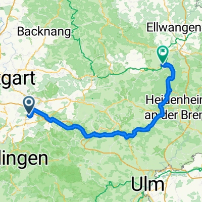
U'ensingen - Lautlingen- Distance
- 92.8 km
- Ascent
- 1,136 m
- Descent
- 720 m
- Location
- Unterensingen, Baden-Wurttemberg, Germany
Schönbuch - Deckenpfronn - BB- Distance
- 82.9 km
- Ascent
- 642 m
- Descent
- 557 m
- Location
- Unterensingen, Baden-Wurttemberg, Germany
Open it in the app

