

Overview
About this route
Zaciatok Cerova 7:55 - 9:46; 18:05 - 19:43
Zaciatok Skalica 8:16 - 9:53; 18:18 - 19:59
- -:--
- Duration
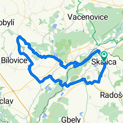
- 66.3 km
- Distance
- 1,219 m
- Ascent
- 1,169 m
- Descent
- ---
- Avg. speed
- 564 m
- Max. altitude

Part of
Jednodenne kopce
2 stages
Route quality
Waytypes & surfaces along the route
Waytypes
Road
37.8 km
(57 %)
Track
11.3 km
(17 %)
Surfaces
Paved
39.8 km
(60 %)
Unpaved
6.6 km
(10 %)
Asphalt
39.8 km
(60 %)
Gravel
6.6 km
(10 %)
Undefined
19.9 km
(30 %)
Route highlights
Points of interest along the route
Point of interest after 28.6 km
Kamenec
Point of interest after 36.2 km
650 rocna lipa
Point of interest after 46.2 km
Husitske hradisko
Continue with Bikemap
Use, edit, or download this cycling route
You would like to ride B08 Skalica - Cerova or customize it for your own trip? Here is what you can do with this Bikemap route:
Free features
- Save this route as favorite or in collections
- Copy & plan your own version of this route
- Sync your route with Garmin or Wahoo
Premium features
Free trial for 3 days, or one-time payment. More about Bikemap Premium.
- Navigate this route on iOS & Android
- Export a GPX / KML file of this route
- Create your custom printout (try it for free)
- Download this route for offline navigation
Discover more Premium features.
Get Bikemap PremiumFrom our community
Other popular routes starting in Skalica
 SKALICKE BUDY 2025
- Distance
- 74.2 km
- Ascent
- 491 m
- Descent
- 490 m
- Location
- Skalica, Trnava Region, Slovakia
 Skalicke rybniky - Batuv kanal - Petrov-Plze
- Distance
- 42.4 km
- Ascent
- 106 m
- Descent
- 103 m
- Location
- Skalica, Trnava Region, Slovakia
 turisticka
- Distance
- 190.6 km
- Ascent
- 1,232 m
- Descent
- 1,221 m
- Location
- Skalica, Trnava Region, Slovakia
 SI - Lanžhot - Brodské - SI
- Distance
- 72.4 km
- Ascent
- 151 m
- Descent
- 151 m
- Location
- Skalica, Trnava Region, Slovakia
 Sporty route in Skalica
- Distance
- 67.9 km
- Ascent
- 1,505 m
- Descent
- 1,508 m
- Location
- Skalica, Trnava Region, Slovakia
 Skalica - Golfový klub - Prietržka - Trnovec - Holíč - Vrádište - Skalica
- Distance
- 18 km
- Ascent
- 119 m
- Descent
- 122 m
- Location
- Skalica, Trnava Region, Slovakia
 Skalica - Kopčany
- Distance
- 18.3 km
- Ascent
- 43 m
- Descent
- 63 m
- Location
- Skalica, Trnava Region, Slovakia
 Skalica - Prietržka - Hrebeň - Trnovec - Holíč - Vrádište - Skalica
- Distance
- 26.4 km
- Ascent
- 159 m
- Descent
- 161 m
- Location
- Skalica, Trnava Region, Slovakia
Open it in the app