

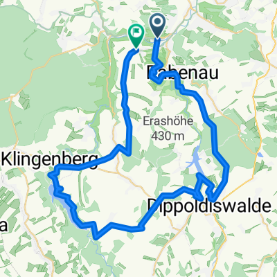
Freitalumrundung
A cycling route starting in Rabenau, Saxony, Germany.
Overview
About this route
Test
- -:--
- Duration
- 49.3 km
- Distance
- 959 m
- Ascent
- 959 m
- Descent
- ---
- Avg. speed
- ---
- Max. altitude
Continue with Bikemap
Use, edit, or download this cycling route
You would like to ride Freitalumrundung or customize it for your own trip? Here is what you can do with this Bikemap route:
Free features
- Save this route as favorite or in collections
- Copy & plan your own version of this route
- Sync your route with Garmin or Wahoo
Premium features
Free trial for 3 days, or one-time payment. More about Bikemap Premium.
- Navigate this route on iOS & Android
- Export a GPX / KML file of this route
- Create your custom printout (try it for free)
- Download this route for offline navigation
Discover more Premium features.
Get Bikemap PremiumFrom our community
Other popular routes starting in Rabenau
 Rabenau - Röthenbach - Rabenau
- Distance
- 39.3 km
- Ascent
- 675 m
- Descent
- 659 m
- Location
- Rabenau, Saxony, Germany
 Oelsa 1
- Distance
- 60.3 km
- Ascent
- 719 m
- Descent
- 720 m
- Location
- Rabenau, Saxony, Germany
 Rabenauer Grund-Malter-Freital-Plauen
- Distance
- 32.7 km
- Ascent
- 294 m
- Descent
- 347 m
- Location
- Rabenau, Saxony, Germany
 2-Talsperren-Runde
- Distance
- 43.3 km
- Ascent
- 563 m
- Descent
- 441 m
- Location
- Rabenau, Saxony, Germany
 Rabenau a okolí
- Distance
- 9.9 km
- Ascent
- 212 m
- Descent
- 364 m
- Location
- Rabenau, Saxony, Germany
 001 Radtour 21.07.2013
- Distance
- 71.8 km
- Ascent
- 1,022 m
- Descent
- 1,022 m
- Location
- Rabenau, Saxony, Germany
 Lilia Ronda - Liliensteinumrundung ...
- Distance
- 193.3 km
- Ascent
- 1,264 m
- Descent
- 1,263 m
- Location
- Rabenau, Saxony, Germany
 Jahreseröffnung 2012
- Distance
- 24.4 km
- Ascent
- 333 m
- Descent
- 331 m
- Location
- Rabenau, Saxony, Germany
Open it in the app