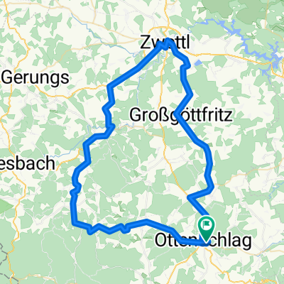
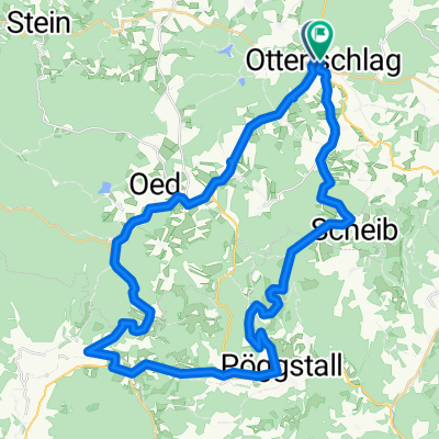
Ottenschlag-Schönbach-Zwettl-Engelbrechts-Ottenschlag
A cycling route starting in Ottenschlag, Lower Austria, Austria.
Overview
About this route
Ottenschlag-Traunstein-Schönbach-Rappottenstein-Merzenstein-Zwettl-Ratschenhof-Großgöttfritz-Engelbrechts-Voitsschlag-Lugendorf-B36 to Ottenschlag
- -:--
- Duration
- 71.9 km
- Distance
- 1,207 m
- Ascent
- 1,213 m
- Descent
- ---
- Avg. speed
- 911 m
- Max. altitude
Route quality
Waytypes & surfaces along the route
Waytypes
Road
20.9 km
(29 %)
Quiet road
1.4 km
(2 %)
Surfaces
Paved
15.1 km
(21 %)
Unpaved
0.7 km
(1 %)
Asphalt
15.1 km
(21 %)
Unpaved (undefined)
0.7 km
(1 %)
Undefined
56.1 km
(78 %)
Continue with Bikemap
Use, edit, or download this cycling route
You would like to ride Ottenschlag-Schönbach-Zwettl-Engelbrechts-Ottenschlag or customize it for your own trip? Here is what you can do with this Bikemap route:
Free features
- Save this route as favorite or in collections
- Copy & plan your own version of this route
- Sync your route with Garmin or Wahoo
Premium features
Free trial for 3 days, or one-time payment. More about Bikemap Premium.
- Navigate this route on iOS & Android
- Export a GPX / KML file of this route
- Create your custom printout (try it for free)
- Download this route for offline navigation
Discover more Premium features.
Get Bikemap PremiumFrom our community
Other popular routes starting in Ottenschlag
Kombitour 17 & 19- Distance
- 46.3 km
- Ascent
- 953 m
- Descent
- 950 m
- Location
- Ottenschlag, Lower Austria, Austria
Kombitour 10 & 17 & 4- Distance
- 40.9 km
- Ascent
- 657 m
- Descent
- 658 m
- Location
- Ottenschlag, Lower Austria, Austria
Waldviertler Hochlandweg CLONED FROM ROUTE 44449- Distance
- 72.9 km
- Ascent
- 780 m
- Descent
- 780 m
- Location
- Ottenschlag, Lower Austria, Austria
Ottenschlag leicht- Distance
- 28.3 km
- Ascent
- 310 m
- Descent
- 318 m
- Location
- Ottenschlag, Lower Austria, Austria
Ottenschlag_Traunstein 1- Distance
- 38.4 km
- Ascent
- 625 m
- Descent
- 623 m
- Location
- Ottenschlag, Lower Austria, Austria
B36 Ottenschlag-Zwettl- Distance
- 23.6 km
- Ascent
- 172 m
- Descent
- 512 m
- Location
- Ottenschlag, Lower Austria, Austria
Ottenschlag - Seiberer- Distance
- 44.7 km
- Ascent
- 968 m
- Descent
- 973 m
- Location
- Ottenschlag, Lower Austria, Austria
Jauerling von Ottenschlag- Distance
- 58.4 km
- Ascent
- 1,617 m
- Descent
- 1,633 m
- Location
- Ottenschlag, Lower Austria, Austria
Open it in the app

