

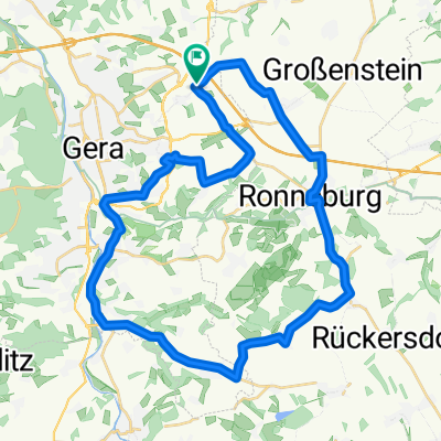
Gera-Ronneburg-Gera
A cycling route starting in Schwaara, Thuringia, Germany.
Overview
About this route
Gera (Trebnitz) - Schwaara - Korbußen - Korbwießen industrial area - Ronneburg - Zeitzer Street - Market - just before Reust (Reuster Tower) - Rußdorf - Hilbersdorf - Niebra Liebschwitz roundabout - Salzstraße - tram terminus loop - Street of People's Friendship - Pforten - Winter Garden - Meuselwitzer Street - Zaufensgraben - CJD/Leumnitz - Thränitz - Naulitz - L1081 - Beerweinschänke roundabout - Selgros/Globus - Trebnitz (bus stop). Complete route filmed and available on Youtube in 15 parts. Cycling loop Gera-Ronneburg-Gera! End of part 12 and start of part 13 not very suitable for racing bikes.
- -:--
- Duration
- 36.4 km
- Distance
- 300 m
- Ascent
- 301 m
- Descent
- ---
- Avg. speed
- ---
- Max. altitude

Route quality
Waytypes & surfaces along the route
Waytypes
Road
7.3 km
(20 %)
Quiet road
7.3 km
(20 %)
Surfaces
Paved
21.1 km
(58 %)
Unpaved
4.4 km
(12 %)
Asphalt
19.7 km
(54 %)
Gravel
2.2 km
(6 %)
Continue with Bikemap
Use, edit, or download this cycling route
You would like to ride Gera-Ronneburg-Gera or customize it for your own trip? Here is what you can do with this Bikemap route:
Free features
- Save this route as favorite or in collections
- Copy & plan your own version of this route
- Sync your route with Garmin or Wahoo
Premium features
Free trial for 3 days, or one-time payment. More about Bikemap Premium.
- Navigate this route on iOS & Android
- Export a GPX / KML file of this route
- Create your custom printout (try it for free)
- Download this route for offline navigation
Discover more Premium features.
Get Bikemap PremiumFrom our community
Other popular routes starting in Schwaara
 Korbußen - Fichtelberg
- Distance
- 111.2 km
- Ascent
- 1,916 m
- Descent
- 995 m
- Location
- Schwaara, Thuringia, Germany
 2021-04-11: Gera - Altenburg
- Distance
- 70.1 km
- Ascent
- 524 m
- Descent
- 523 m
- Location
- Schwaara, Thuringia, Germany
 Gera-Glauchau-Chemnitz
- Distance
- 89.8 km
- Ascent
- 472 m
- Descent
- 449 m
- Location
- Schwaara, Thuringia, Germany
 Route nach Bauvereinstraße 23, Gera
- Distance
- 6.5 km
- Ascent
- 66 m
- Descent
- 136 m
- Location
- Schwaara, Thuringia, Germany
 Gera-Ronneburg-Gera
- Distance
- 36.4 km
- Ascent
- 300 m
- Descent
- 301 m
- Location
- Schwaara, Thuringia, Germany
 probe
probe- Distance
- 2.7 km
- Ascent
- 19 m
- Descent
- 19 m
- Location
- Schwaara, Thuringia, Germany
 Rundkurs Gera-Ronneburg-Wünschendorf -Gera
- Distance
- 41.1 km
- Ascent
- 332 m
- Descent
- 332 m
- Location
- Schwaara, Thuringia, Germany
 Korbußen 67 nach Markt 6A, Crossen an der Elster
- Distance
- 21.9 km
- Ascent
- 81 m
- Descent
- 205 m
- Location
- Schwaara, Thuringia, Germany
Open it in the app