
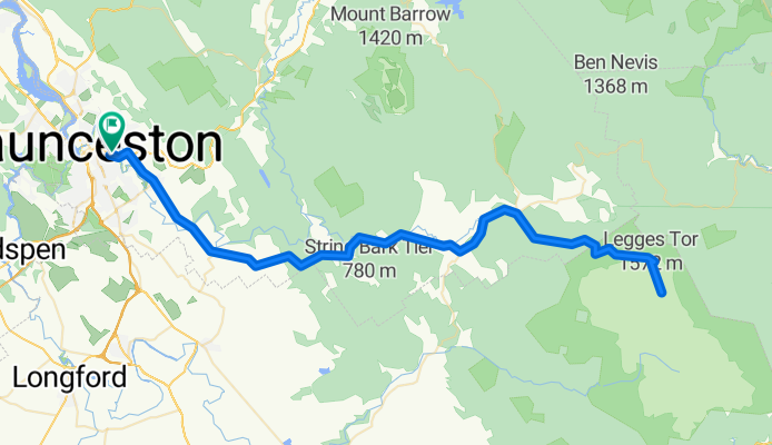
LAUNCESTON - JACOBS LADDER
A cycling route starting in East Launceston, Tasmania, Australia.
Overview
About this route
launceston , jacobs ladder , launceston
- -:--
- Duration
- 115.8 km
- Distance
- 1,548 m
- Ascent
- 1,552 m
- Descent
- ---
- Avg. speed
- ---
- Max. altitude
Route quality
Waytypes & surfaces along the route
Waytypes
Cycleway
4.6 km
(4 %)
Road
2.3 km
(2 %)
Surfaces
Paved
71.8 km
(62 %)
Unpaved
42.9 km
(37 %)
Paved (undefined)
63.7 km
(55 %)
Gravel
42.9 km
(37 %)
Continue with Bikemap
Use, edit, or download this cycling route
You would like to ride LAUNCESTON - JACOBS LADDER or customize it for your own trip? Here is what you can do with this Bikemap route:
Free features
- Save this route as favorite or in collections
- Copy & plan your own version of this route
- Split it into stages to create a multi-day tour
- Sync your route with Garmin or Wahoo
Premium features
Free trial for 3 days, or one-time payment. More about Bikemap Premium.
- Navigate this route on iOS & Android
- Export a GPX / KML file of this route
- Create your custom printout (try it for free)
- Download this route for offline navigation
Discover more Premium features.
Get Bikemap PremiumFrom our community
Other popular routes starting in East Launceston
 Launceston - Jacobs Ladder
- Distance
- 115.8 km
- Ascent
- 1,563 m
- Descent
- 1,565 m
- Location
- East Launceston, Tasmania, Australia
 Home Longford
- Distance
- 24 km
- Ascent
- 257 m
- Descent
- 170 m
- Location
- East Launceston, Tasmania, Australia
 Quick bike tour from 4/10/16, 7:03 pm
- Distance
- 4.3 km
- Ascent
- 25 m
- Descent
- 4 m
- Location
- East Launceston, Tasmania, Australia
 Bothwell via Poatina
- Distance
- 143.9 km
- Ascent
- 1,680 m
- Descent
- 1,330 m
- Location
- East Launceston, Tasmania, Australia
 French St to Poatina
- Distance
- 69.6 km
- Ascent
- 1,220 m
- Descent
- 172 m
- Location
- East Launceston, Tasmania, Australia
 Tasi No Brainer (Launy to Hobby)
- Distance
- 341.1 km
- Ascent
- 1,056 m
- Descent
- 1,067 m
- Location
- East Launceston, Tasmania, Australia
 Home to Ride Start
- Distance
- 2.9 km
- Ascent
- 11 m
- Descent
- 66 m
- Location
- East Launceston, Tasmania, Australia
 LAUNCESTON - JACOBS LADDER
- Distance
- 115.8 km
- Ascent
- 1,548 m
- Descent
- 1,552 m
- Location
- East Launceston, Tasmania, Australia
Open it in the app