

RoztoczeZachodnie_2014_PierwszyDzien
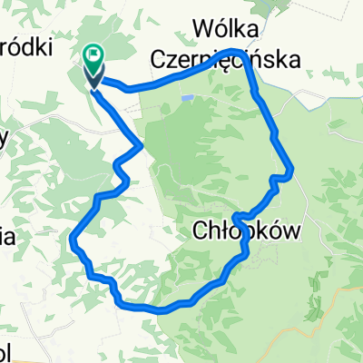
A cycling route starting in Radecznica, Lublin Voivodeship, Poland.
Overview
About this route
<span style="color: rgb(102, 102, 102); font-family: ProximaNovaSoft-Regular, Helvetica, 'Helvetica Neue', sans-serif; font-size: 13px; line-height: 18.8159999847412px;">Kolejny wyjazd na Roztocze</span>
- -:--
- Duration
- 51.4 km
- Distance
- 330 m
- Ascent
- 328 m
- Descent
- ---
- Avg. speed
- ---
- Max. altitude

Route quality
Waytypes & surfaces along the route
Waytypes
Track
18.6 km
(36 %)
Quiet road
14.4 km
(28 %)
Surfaces
Paved
24.5 km
(48 %)
Unpaved
19.3 km
(37 %)
Asphalt
23.6 km
(46 %)
Ground
16.9 km
(33 %)
Continue with Bikemap
Use, edit, or download this cycling route
You would like to ride RoztoczeZachodnie_2014_PierwszyDzien or customize it for your own trip? Here is what you can do with this Bikemap route:
Free features
- Save this route as favorite or in collections
- Copy & plan your own version of this route
- Sync your route with Garmin or Wahoo
Premium features
Free trial for 3 days, or one-time payment. More about Bikemap Premium.
- Navigate this route on iOS & Android
- Export a GPX / KML file of this route
- Create your custom printout (try it for free)
- Download this route for offline navigation
Discover more Premium features.
Get Bikemap PremiumFrom our community
Other popular routes starting in Radecznica
 Łysiec do Średniówka
- Distance
- 21.5 km
- Ascent
- 96 m
- Descent
- 201 m
- Location
- Radecznica, Lublin Voivodeship, Poland
 RoztoczeZachodnie_2014_PierwszyDzien
- Distance
- 51.4 km
- Ascent
- 330 m
- Descent
- 328 m
- Location
- Radecznica, Lublin Voivodeship, Poland
 Gilów, Goraj do Gilów, Goraj
- Distance
- 32.9 km
- Ascent
- 337 m
- Descent
- 337 m
- Location
- Radecznica, Lublin Voivodeship, Poland
 RoztoczeZachodnie_2014_DrugiDzien
- Distance
- 55.9 km
- Ascent
- 272 m
- Descent
- 272 m
- Location
- Radecznica, Lublin Voivodeship, Poland
 Gruszka Zaporska do Przyjaźni 6, Zamość
- Distance
- 31.9 km
- Ascent
- 10 m
- Descent
- 25 m
- Location
- Radecznica, Lublin Voivodeship, Poland
 podjazd
- Distance
- 1.9 km
- Ascent
- 108 m
- Descent
- 5 m
- Location
- Radecznica, Lublin Voivodeship, Poland
 majówka_2012_d8
- Distance
- 82.2 km
- Ascent
- 258 m
- Descent
- 352 m
- Location
- Radecznica, Lublin Voivodeship, Poland
 Klasztorna 8, Radecznica do Czarnystok 54–64, Radecznica
- Distance
- 14.9 km
- Ascent
- 418 m
- Descent
- 419 m
- Location
- Radecznica, Lublin Voivodeship, Poland
Open it in the app