

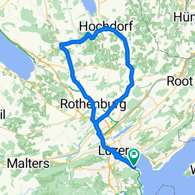
Challenge Tour: Lucerne -> Rapperswil
A cycling route starting in Lucerne, Canton of Lucerne, Switzerland.
Overview
About this route
Challenge Tour: Lucerne -> Rapperswil
- -:--
- Duration
- 98.8 km
- Distance
- 846 m
- Ascent
- 859 m
- Descent
- ---
- Avg. speed
- ---
- Max. altitude

Route quality
Waytypes & surfaces along the route
Waytypes
Quiet road
27.7 km
(28 %)
Track
20.7 km
(21 %)
Surfaces
Paved
67.2 km
(68 %)
Unpaved
13.8 km
(14 %)
Asphalt
65.2 km
(66 %)
Gravel
11.9 km
(12 %)
Route highlights
Points of interest along the route

Point of interest after 98.7 km
Hotel Jakob, Rapperswil
Continue with Bikemap
Use, edit, or download this cycling route
You would like to ride Challenge Tour: Lucerne -> Rapperswil or customize it for your own trip? Here is what you can do with this Bikemap route:
Free features
- Save this route as favorite or in collections
- Copy & plan your own version of this route
- Split it into stages to create a multi-day tour
- Sync your route with Garmin or Wahoo
Premium features
Free trial for 3 days, or one-time payment. More about Bikemap Premium.
- Navigate this route on iOS & Android
- Export a GPX / KML file of this route
- Create your custom printout (try it for free)
- Download this route for offline navigation
Discover more Premium features.
Get Bikemap PremiumFrom our community
Other popular routes starting in Lucerne
 Luzern - Kehrsitenbürgenstock
- Distance
- 15.1 km
- Ascent
- 317 m
- Descent
- 346 m
- Location
- Lucerne, Canton of Lucerne, Switzerland
 Rotkreuz-Meierskappel-Küssnacht-Udligenswil-Adligenswil
- Distance
- 35 km
- Ascent
- 357 m
- Descent
- 355 m
- Location
- Lucerne, Canton of Lucerne, Switzerland
 Abendausfahrt Luzern Hochdorf Hildisrieden
- Distance
- 44.2 km
- Ascent
- 508 m
- Descent
- 494 m
- Location
- Lucerne, Canton of Lucerne, Switzerland
 Durschnei via Kriens
- Distance
- 24.1 km
- Ascent
- 567 m
- Descent
- 573 m
- Location
- Lucerne, Canton of Lucerne, Switzerland
 Challenge Tour: Lucerne -> Rapperswil
- Distance
- 98.8 km
- Ascent
- 846 m
- Descent
- 859 m
- Location
- Lucerne, Canton of Lucerne, Switzerland
 Rigi-Scheidegg
- Distance
- 79.8 km
- Ascent
- 1,299 m
- Descent
- 1,299 m
- Location
- Lucerne, Canton of Lucerne, Switzerland
 Vierwaldstättersee Tour
- Distance
- 98.8 km
- Ascent
- 828 m
- Descent
- 827 m
- Location
- Lucerne, Canton of Lucerne, Switzerland
 Luzern - Obernau - Fräki - Luzern
- Distance
- 23.8 km
- Ascent
- 1,014 m
- Descent
- 1,015 m
- Location
- Lucerne, Canton of Lucerne, Switzerland
Open it in the app