

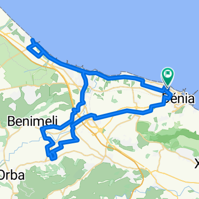
156 km - Denia-Rates-Guadalest-Gorga-Toios-Ebo-Tormos-Orba-Denia
A cycling route starting in Denia, Valencia, Spain.
Overview
About this route
Denia-Rates-Guadalest-Gorga-Toios-Ebo-Tormos-Orba-Denia
156 km - -:--
- Duration
- 156.4 km
- Distance
- 1,948 m
- Ascent
- 1,940 m
- Descent
- ---
- Avg. speed
- ---
- Max. altitude

Route quality
Waytypes & surfaces along the route
Waytypes
Road
7.8 km
(5 %)
Quiet road
1.6 km
(1 %)
Surfaces
Paved
134.5 km
(86 %)
Unpaved
1.6 km
(1 %)
Asphalt
134.5 km
(86 %)
Gravel
1.6 km
(1 %)
Undefined
20.3 km
(13 %)
Continue with Bikemap
Use, edit, or download this cycling route
You would like to ride 156 km - Denia-Rates-Guadalest-Gorga-Toios-Ebo-Tormos-Orba-Denia or customize it for your own trip? Here is what you can do with this Bikemap route:
Free features
- Save this route as favorite or in collections
- Copy & plan your own version of this route
- Split it into stages to create a multi-day tour
- Sync your route with Garmin or Wahoo
Premium features
Free trial for 3 days, or one-time payment. More about Bikemap Premium.
- Navigate this route on iOS & Android
- Export a GPX / KML file of this route
- Create your custom printout (try it for free)
- Download this route for offline navigation
Discover more Premium features.
Get Bikemap PremiumFrom our community
Other popular routes starting in Denia
 9ijo..gracias. 9n.mmmlll.De Carrer Bacallà a Carrer Bacallà
- Distance
- 52.1 km
- Ascent
- 248 m
- Descent
- 247 m
- Location
- Denia, Valencia, Spain
 SAC Vuelta Via Verdes Rondrit vanuit Denia
- Distance
- 39.5 km
- Ascent
- 423 m
- Descent
- 423 m
- Location
- Denia, Valencia, Spain
 DENIA- JESÚS POBRE- GATA- LA XARA- DENIA
- Distance
- 41.3 km
- Ascent
- 475 m
- Descent
- 474 m
- Location
- Denia, Valencia, Spain
 156 km - Denia-Rates-Guadalest-Gorga-Toios-Ebo-Tormos-Orba-Denia
- Distance
- 156.4 km
- Ascent
- 1,948 m
- Descent
- 1,940 m
- Location
- Denia, Valencia, Spain
 Salida 9-11-2011 TCAF "A" (Pueblo Fantasma)
- Distance
- 16 km
- Ascent
- 225 m
- Descent
- 224 m
- Location
- Denia, Valencia, Spain
 2016-08agosto-13 - FAMORCA
- Distance
- 108.2 km
- Ascent
- 1,033 m
- Descent
- 1,032 m
- Location
- Denia, Valencia, Spain
 Salida montaña
- Distance
- 7.7 km
- Ascent
- 791 m
- Descent
- 787 m
- Location
- Denia, Valencia, Spain
 Ruta Pico de L'Aguila
- Distance
- 6.8 km
- Ascent
- 574 m
- Descent
- 512 m
- Location
- Denia, Valencia, Spain
Open it in the app