

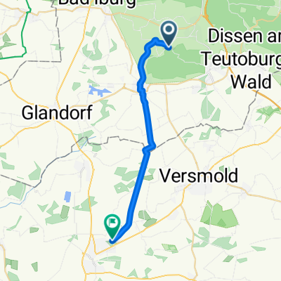
emsländerroute
A cycling route starting in Hilter, Lower Saxony, Germany.
Overview
About this route
lockere mtb tour.schotter,waldboden,felsiger boden.
- -:--
- Duration
- 15.4 km
- Distance
- 393 m
- Ascent
- 393 m
- Descent
- ---
- Avg. speed
- ---
- Max. altitude
Continue with Bikemap
Use, edit, or download this cycling route
You would like to ride emsländerroute or customize it for your own trip? Here is what you can do with this Bikemap route:
Free features
- Save this route as favorite or in collections
- Copy & plan your own version of this route
- Sync your route with Garmin or Wahoo
Premium features
Free trial for 3 days, or one-time payment. More about Bikemap Premium.
- Navigate this route on iOS & Android
- Export a GPX / KML file of this route
- Create your custom printout (try it for free)
- Download this route for offline navigation
Discover more Premium features.
Get Bikemap PremiumFrom our community
Other popular routes starting in Hilter
 Aussichtsturm Fun
- Distance
- 34.8 km
- Ascent
- 609 m
- Descent
- 609 m
- Location
- Hilter, Lower Saxony, Germany
 Kalte Nachtfahrt im Wald
- Distance
- 14.1 km
- Ascent
- 182 m
- Descent
- 182 m
- Location
- Hilter, Lower Saxony, Germany
 Die Olaf Tour
- Distance
- 25.5 km
- Ascent
- 178 m
- Descent
- 178 m
- Location
- Hilter, Lower Saxony, Germany
 Remsede - Feldmarksee
- Distance
- 17.3 km
- Ascent
- 19 m
- Descent
- 70 m
- Location
- Hilter, Lower Saxony, Germany
 emsländerroute
- Distance
- 15.4 km
- Ascent
- 393 m
- Descent
- 393 m
- Location
- Hilter, Lower Saxony, Germany
 Regen Tour
- Distance
- 19 km
- Ascent
- 249 m
- Descent
- 251 m
- Location
- Hilter, Lower Saxony, Germany
 Lange Radrunde durch Hilter am Teutoburger Wald
- Distance
- 79.3 km
- Ascent
- 514 m
- Descent
- 516 m
- Location
- Hilter, Lower Saxony, Germany
 2. Strecke am 26.02.2010 von Sabse und Achilles
- Distance
- 11.3 km
- Ascent
- 63 m
- Descent
- 55 m
- Location
- Hilter, Lower Saxony, Germany
Open it in the app