

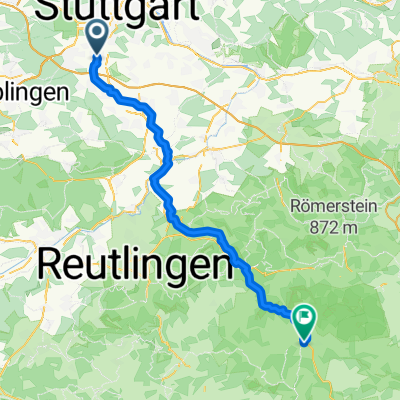
Möhringen - Feuerwache 3
A cycling route starting in Leinfelden-Echterdingen, Baden-Wurttemberg, Germany.
Overview
About this route
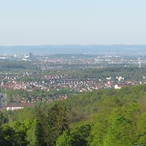
From Möhringen to Degerloch asphalt and mostly bike paths. In Degerloch, from Königssträßle to Pischeckstr forest path (gravel). Then downhill on the road to SWR. Then park and across the Wasen.
- -:--
- Duration
- 13.1 km
- Distance
- 108 m
- Ascent
- 312 m
- Descent
- ---
- Avg. speed
- ---
- Max. altitude
Continue with Bikemap
Use, edit, or download this cycling route
You would like to ride Möhringen - Feuerwache 3 or customize it for your own trip? Here is what you can do with this Bikemap route:
Free features
- Save this route as favorite or in collections
- Copy & plan your own version of this route
- Sync your route with Garmin or Wahoo
Premium features
Free trial for 3 days, or one-time payment. More about Bikemap Premium.
- Navigate this route on iOS & Android
- Export a GPX / KML file of this route
- Create your custom printout (try it for free)
- Download this route for offline navigation
Discover more Premium features.
Get Bikemap PremiumFrom our community
Other popular routes starting in Leinfelden-Echterdingen
 Steckfeld - RadelThon - Botnang - West - Heslach - Zacke - Degerloch - Möhringen - Steckfeld
- Distance
- 44 km
- Ascent
- 508 m
- Descent
- 507 m
- Location
- Leinfelden-Echterdingen, Baden-Wurttemberg, Germany
 Neuffen - Bad Urach
- Distance
- 131.9 km
- Ascent
- 2,283 m
- Descent
- 2,311 m
- Location
- Leinfelden-Echterdingen, Baden-Wurttemberg, Germany
 Wasweißdennichwoichwar...
- Distance
- 33.8 km
- Ascent
- 368 m
- Descent
- 518 m
- Location
- Leinfelden-Echterdingen, Baden-Wurttemberg, Germany
 Möhringen - Bad Uracher Wasserfall 41km 450hm
- Distance
- 40.8 km
- Ascent
- 364 m
- Descent
- 326 m
- Location
- Leinfelden-Echterdingen, Baden-Wurttemberg, Germany
 Leinfelden-Echterdingen - Westerheim
- Distance
- 59.4 km
- Ascent
- 1,118 m
- Descent
- 829 m
- Location
- Leinfelden-Echterdingen, Baden-Wurttemberg, Germany
 Filder,Schönbuch, Remstal, Stuttgart
- Distance
- 74.7 km
- Ascent
- 658 m
- Descent
- 643 m
- Location
- Leinfelden-Echterdingen, Baden-Wurttemberg, Germany
 Oberaichen - Schlosssolitude
- Distance
- 46.2 km
- Ascent
- 422 m
- Descent
- 421 m
- Location
- Leinfelden-Echterdingen, Baden-Wurttemberg, Germany
 Filderhauptstraße, Stuttgart nach Oskar-Schlemmer-Weg, Ostfildern
- Distance
- 6.9 km
- Ascent
- 108 m
- Descent
- 113 m
- Location
- Leinfelden-Echterdingen, Baden-Wurttemberg, Germany
Open it in the app