15) St GenisLaval - Condrieu
A cycling route starting in Saint-Genis-Laval, Auvergne-Rh么ne-Alpes, France.
Overview
About this route
2015
(cloned from route 2830097)
- -:--
- Duration
- 42.1 km
- Distance
- 156 m
- Ascent
- 224 m
- Descent
- ---
- Avg. speed
- ---
- Max. altitude
Route quality
Waytypes & surfaces along the route
Waytypes
Quiet road
10.1 km
(24 %)
Road
3.8 km
(9 %)
Surfaces
Paved
24.4 km
(58 %)
Unpaved
1.7 km
(4 %)
Asphalt
24.4 km
(58 %)
Ground
1.7 km
(4 %)
Undefined
16 km
(38 %)
Continue with Bikemap
Use, edit, or download this cycling route
You would like to ride 15) St GenisLaval - Condrieu or customize it for your own trip? Here is what you can do with this Bikemap route:
Free features
- Save this route as favorite or in collections
- Copy & plan your own version of this route
- Sync your route with Garmin or Wahoo
Premium features
Free trial for 3 days, or one-time payment. More about Bikemap Premium.
- Navigate this route on iOS & Android
- Export a GPX / KML file of this route
- Create your custom printout (try it for free)
- Download this route for offline navigation
Discover more Premium features.
Get Bikemap PremiumFrom our community
Other popular routes starting in Saint-Genis-Laval
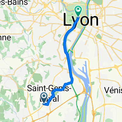
- Etapa 081B (Saint Genis Laval - Saint Nazaire en Royans)
- Distance
- 159.3 km
- Ascent
- 674 m
- Descent
- 729 m
- Location
- Saint-Genis-Laval, Auvergne-Rh么ne-Alpes, France
- San Denis Laval - Saint Rambert d'Albon
- Distance
- 78.6 km
- Ascent
- 830 m
- Descent
- 955 m
- Location
- Saint-Genis-Laval, Auvergne-Rh么ne-Alpes, France
- Tag 32: Saint-Genis-Laval-Condrieu
- Distance
- 38 km
- Ascent
- 284 m
- Descent
- 363 m
- Location
- Saint-Genis-Laval, Auvergne-Rh么ne-Alpes, France
- SGL
- Distance
- 4.3 km
- Ascent
- 42 m
- Descent
- 49 m
- Location
- Saint-Genis-Laval, Auvergne-Rh么ne-Alpes, France
- Saint-Genis-Saint V茅rand
- Distance
- 42.1 km
- Ascent
- 715 m
- Descent
- 558 m
- Location
- Saint-Genis-Laval, Auvergne-Rh么ne-Alpes, France
- 15) St GenisLaval - Condrieu
- Distance
- 42.1 km
- Ascent
- 156 m
- Descent
- 224 m
- Location
- Saint-Genis-Laval, Auvergne-Rh么ne-Alpes, France
- Lyon Gre par le Vercors
- Distance
- 192 km
- Ascent
- 2,299 m
- Descent
- 2,312 m
- Location
- Saint-Genis-Laval, Auvergne-Rh么ne-Alpes, France
- Avenue Mar茅chal Foch 88, Saint-Genis-Laval nach Chemin des Montats 122, Vion
- Distance
- 87.8 km
- Ascent
- 349 m
- Descent
- 437 m
- Location
- Saint-Genis-Laval, Auvergne-Rh么ne-Alpes, France
Open it in the app