

Ortenberger Runde (RB 090-625)
A cycling route starting in Bad Vilbel, Hesse, Germany.
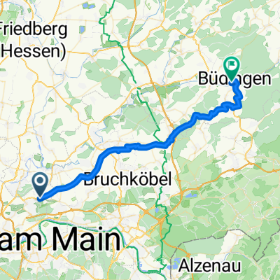
Overview
About this route
The route begins at Riedbad in the Bergen-Enkheim district of Frankfurt. From there, the route immediately leads to the short but steep climb of the street 'Am Bächelchen'. It then continues along Marktstraße to Hohe Straße, and from there along the Hessian long-distance cycle path R4 to the Nidda near Gronau.
We now follow the Nidda route northeast. The cycle path has been almost entirely asphalted in recent years. Only a few short sections are still gravel and are avoided here, since it is meant to be a road bike route.
In Dauernheim, we leave the Nidda route and ride on lightly trafficked country roads via Ranstadt, Bellmuth, and Bobenhausen to Ortenberg.
Here we continue southwest, first on the Vulkanradweg cycle path, then later on Hohe Straße back to Frankfurt Bergen-Enkheim.
- -:--
- Duration
- 89.7 km
- Distance
- 376 m
- Ascent
- 376 m
- Descent
- ---
- Avg. speed
- ---
- Max. altitude
Route quality
Waytypes & surfaces along the route
Waytypes
Track
47.6 km
(53 %)
Quiet road
11.7 km
(13 %)
Surfaces
Paved
81.7 km
(91 %)
Unpaved
0.9 km
(1 %)
Asphalt
80.8 km
(90 %)
Paved (undefined)
0.9 km
(1 %)
Continue with Bikemap
Use, edit, or download this cycling route
You would like to ride Ortenberger Runde (RB 090-625) or customize it for your own trip? Here is what you can do with this Bikemap route:
Free features
- Save this route as favorite or in collections
- Copy & plan your own version of this route
- Split it into stages to create a multi-day tour
- Sync your route with Garmin or Wahoo
Premium features
Free trial for 3 days, or one-time payment. More about Bikemap Premium.
- Navigate this route on iOS & Android
- Export a GPX / KML file of this route
- Create your custom printout (try it for free)
- Download this route for offline navigation
Discover more Premium features.
Get Bikemap PremiumFrom our community
Other popular routes starting in Bad Vilbel
 R.Anglerheim am Nidda_ImM_T_N_via nur Nidda
- Distance
- 10.6 km
- Ascent
- 25 m
- Descent
- 44 m
- Location
- Bad Vilbel, Hesse, Germany
 Hohe Straße - Burg Ronneburg und weiter
- Distance
- 109.3 km
- Ascent
- 603 m
- Descent
- 601 m
- Location
- Bad Vilbel, Hesse, Germany
 OPEL Zoo_ImM_T_via Riedberg, Weisskirchen, Kronberg
- Distance
- 19.1 km
- Ascent
- 286 m
- Descent
- 104 m
- Location
- Bad Vilbel, Hesse, Germany
 Regionalpark Route Hohe Strasse - Entree Bergen-Enkheim - Hopfünf - Regionalpark RheinMain Infostand - Stationen am Lausbaum - Blühfläche Windrad - Leseecke ...
- Distance
- 38 km
- Ascent
- 250 m
- Descent
- 309 m
- Location
- Bad Vilbel, Hesse, Germany
 Römerkastell Saalburg_ImM_T_via Bonames, Eschbach, Kirdorf
- Distance
- 19.1 km
- Ascent
- 355 m
- Descent
- 39 m
- Location
- Bad Vilbel, Hesse, Germany
 Büdinger-Runde M (RB 091-0450)
- Distance
- 93.1 km
- Ascent
- 314 m
- Descent
- 313 m
- Location
- Bad Vilbel, Hesse, Germany
 BW Depot - Friedrichstahl - Wiesental
- Distance
- 68.3 km
- Ascent
- 629 m
- Descent
- 629 m
- Location
- Bad Vilbel, Hesse, Germany
 Ronneburgrunde südlich (RB 073 - 0340)
- Distance
- 73.2 km
- Ascent
- 321 m
- Descent
- 321 m
- Location
- Bad Vilbel, Hesse, Germany
Open it in the app