

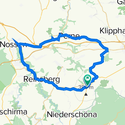
Nossen-Birkenhain-Runde
A cycling route starting in Niederschöna, Saxony, Germany.
Overview
About this route
zwischen Nossen,Mohorn und Siebenlehn auf alten Bahntrassen und Straßen unterwegs
- -:--
- Duration
- 41 km
- Distance
- 301 m
- Ascent
- 306 m
- Descent
- ---
- Avg. speed
- 356 m
- Max. altitude

Route quality
Waytypes & surfaces along the route
Waytypes
Quiet road
8.5 km
(21 %)
Path
8.5 km
(21 %)
Surfaces
Paved
23 km
(56 %)
Unpaved
12.3 km
(30 %)
Asphalt
22.5 km
(55 %)
Gravel
6.6 km
(16 %)
Continue with Bikemap
Use, edit, or download this cycling route
You would like to ride Nossen-Birkenhain-Runde or customize it for your own trip? Here is what you can do with this Bikemap route:
Free features
- Save this route as favorite or in collections
- Copy & plan your own version of this route
- Sync your route with Garmin or Wahoo
Premium features
Free trial for 3 days, or one-time payment. More about Bikemap Premium.
- Navigate this route on iOS & Android
- Export a GPX / KML file of this route
- Create your custom printout (try it for free)
- Download this route for offline navigation
Discover more Premium features.
Get Bikemap PremiumFrom our community
Other popular routes starting in Niederschöna
 Halsbrücke-Rothenfurth
- Distance
- 18.6 km
- Ascent
- 227 m
- Descent
- 227 m
- Location
- Niederschöna, Saxony, Germany
 Falkenbeg Kuhstall na.Falkenberg Schloß
- Distance
- 99.6 km
- Ascent
- 400 m
- Descent
- 675 m
- Location
- Niederschöna, Saxony, Germany
 Naundorf- Rechenberger Brauerei
- Distance
- 40.1 km
- Ascent
- 612 m
- Descent
- 378 m
- Location
- Niederschöna, Saxony, Germany
 Nossen-Birkenhain-Runde
- Distance
- 41 km
- Ascent
- 301 m
- Descent
- 306 m
- Location
- Niederschöna, Saxony, Germany
 Dorfstraße 58, Halsbrücke nach Dorfstraße 58, Halsbrücke
- Distance
- 5.9 km
- Ascent
- 102 m
- Descent
- 98 m
- Location
- Niederschöna, Saxony, Germany
 TARANDTER WALD
- Distance
- 39.2 km
- Ascent
- 474 m
- Descent
- 491 m
- Location
- Niederschöna, Saxony, Germany
 Naundorf- Lichtenberger Talsperre-Naundorf
- Distance
- 39.4 km
- Ascent
- 345 m
- Descent
- 307 m
- Location
- Niederschöna, Saxony, Germany
 Naundorf -Talsperre Malter
- Distance
- 19.2 km
- Ascent
- 269 m
- Descent
- 291 m
- Location
- Niederschöna, Saxony, Germany
Open it in the app