

Kreuzberg to Treptow
A cycling route starting in Kreuzberg, State of Berlin, Germany.
Overview
About this route
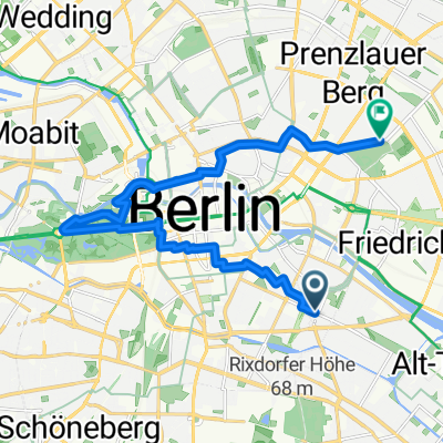
Slightly modified version of my training route. Starting point Urbanstraße, just straight ahead until Körtestraße. Here is the last 'relevant' traffic light for now. Turn left towards Planufer and from there always nicely eastwards along the Landwehr Canal towards Treptow. and so on. Once you reach the Rummelsburger See, it's all clear of traffic lights. Here, only occasionally pedestrians are a nuisance :). You circumnavigate the old Plänterwald in the green area. I always do 6-7 laps here and then return via the 96 (Alt-Treptow) back to the heart of Kreuzberg. [With the extra laps, the total is about 50 km]
- -:--
- Duration
- 19.9 km
- Distance
- 48 m
- Ascent
- 46 m
- Descent
- ---
- Avg. speed
- 46 m
- Max. altitude
Route quality
Waytypes & surfaces along the route
Waytypes
Path
7.7 km
(39 %)
Quiet road
5 km
(25 %)
Surfaces
Paved
12.1 km
(61 %)
Unpaved
2.6 km
(13 %)
Asphalt
11.7 km
(59 %)
Loose gravel
1.8 km
(9 %)
Continue with Bikemap
Use, edit, or download this cycling route
You would like to ride Kreuzberg to Treptow or customize it for your own trip? Here is what you can do with this Bikemap route:
Free features
- Save this route as favorite or in collections
- Copy & plan your own version of this route
- Sync your route with Garmin or Wahoo
Premium features
Free trial for 3 days, or one-time payment. More about Bikemap Premium.
- Navigate this route on iOS & Android
- Export a GPX / KML file of this route
- Create your custom printout (try it for free)
- Download this route for offline navigation
Discover more Premium features.
Get Bikemap PremiumFrom our community
Other popular routes starting in Kreuzberg
 Klassische Westberliner Runde
- Distance
- 80.9 km
- Ascent
- 554 m
- Descent
- 561 m
- Location
- Kreuzberg, State of Berlin, Germany
 Tag 2 Mauerradweg Kreuzberg nach Potsdam
- Distance
- 74.7 km
- Ascent
- 72 m
- Descent
- 73 m
- Location
- Kreuzberg, State of Berlin, Germany
 Lange Westrunde
- Distance
- 120.8 km
- Ascent
- 520 m
- Descent
- 523 m
- Location
- Kreuzberg, State of Berlin, Germany
 Trainingsrunde1
- Distance
- 90.3 km
- Ascent
- 299 m
- Descent
- 292 m
- Location
- Kreuzberg, State of Berlin, Germany
 Sacrow kurz mit Caputh
- Distance
- 92.1 km
- Ascent
- 335 m
- Descent
- 338 m
- Location
- Kreuzberg, State of Berlin, Germany
 Urbify Team Event
- Distance
- 14.4 km
- Ascent
- 53 m
- Descent
- 43 m
- Location
- Kreuzberg, State of Berlin, Germany
 Kreuzberg to Treptow
- Distance
- 19.9 km
- Ascent
- 48 m
- Descent
- 46 m
- Location
- Kreuzberg, State of Berlin, Germany
 Berlin Tag 2
- Distance
- 51.5 km
- Ascent
- 230 m
- Descent
- 234 m
- Location
- Kreuzberg, State of Berlin, Germany
Open it in the app