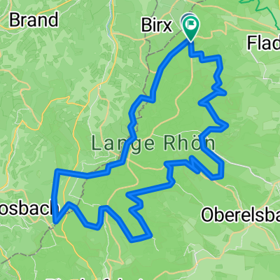
Röhntour, zweite Etappe
- 77.2 km
- 444 m
- 794 m
- Birx, Thuringia, Germany
A cycling route starting in Birx, Thuringia, Germany.
Overview
An alternative panoramic tour over the High Rhön
In the area of the Hochrhön, between Bischofsheim (Oberweißenbrunn) and Fladungen (modified* to 'up to the foot of Stirnberg'), there is for mountain lovers or for people who don’t mind pushing a few meters, with the alternative route, an incomparably beautiful panoramic route through the nature reserve Lange Rhön, an 'open landscape' created by deforestation in the Middle Ages. Today it not only hosts several raised bogs but is also a habitat and refuge for rare animals and plants. Not least for this reason, the Rhön was awarded the title of 'Biosphere Reserve'. (The alternative route is not part of the quality cycling path) *Transformation into a circular route from Bischofsheim (Start/Finish mistakenly at the peak) Length: circular route = approx. 35 km Duration: approx. 5 h, probably shorter - Descent 8.4% over 4 km (white road towards Ginolfs) (cloned from route 429827)created this 11 years ago
Route quality
Track
10.5 km
(30 %)
Road
8 km
(23 %)
Paved
23.7 km
(68 %)
Unpaved
6.6 km
(19 %)
Asphalt
22.7 km
(65 %)
Gravel
6.3 km
(18 %)
Continue with Bikemap
You would like to ride Rhön: Panoramatour bei Bischofsheim or customize it for your own trip? Here is what you can do with this Bikemap route:
Free trial for 3 days, or one-time payment. More about Bikemap Premium.
Discover more Premium features.
Get Bikemap PremiumFrom our community
Open it in the app