

Jubiläumsgrad
A cycling route starting in Höfen, Tyrol, Austria.
Overview
About this route
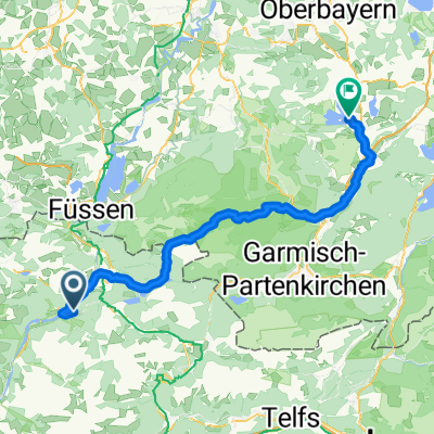
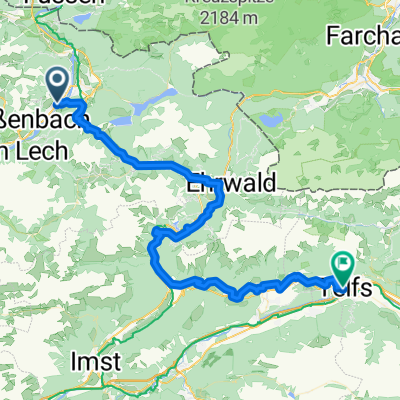
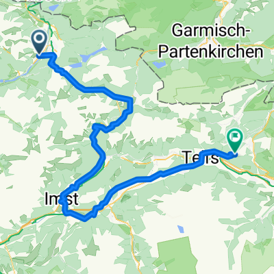
By bike across Plansee to Garmisch, ascent to the Alpspitze and overnight in a bivouac shelter. The next day continuing to the Zugspitze, descent through the Hölltal and cycling back to Reutte.
- -:--
- Duration
- 89.4 km
- Distance
- 2,760 m
- Ascent
- 2,760 m
- Descent
- ---
- Avg. speed
- ---
- Max. altitude

Route highlights
Points of interest along the route
Point of interest after 43.1 km
Bufack
Continue with Bikemap
Use, edit, or download this cycling route
You would like to ride Jubiläumsgrad or customize it for your own trip? Here is what you can do with this Bikemap route:
Free features
- Save this route as favorite or in collections
- Copy & plan your own version of this route
- Split it into stages to create a multi-day tour
- Sync your route with Garmin or Wahoo
Premium features
Free trial for 3 days, or one-time payment. More about Bikemap Premium.
- Navigate this route on iOS & Android
- Export a GPX / KML file of this route
- Create your custom printout (try it for free)
- Download this route for offline navigation
Discover more Premium features.
Get Bikemap PremiumFrom our community
Other popular routes starting in Höfen
 Von Ehenbichl bis Seehausen am Staffelsee
- Distance
- 77.2 km
- Ascent
- 1,101 m
- Descent
- 1,339 m
- Location
- Höfen, Tyrol, Austria
 Lechaschau - Zirl
- Distance
- 67 km
- Ascent
- 1,606 m
- Descent
- 1,841 m
- Location
- Höfen, Tyrol, Austria
 Rund um die Allgäuer Alpen
- Distance
- 182.5 km
- Ascent
- 3,790 m
- Descent
- 3,672 m
- Location
- Höfen, Tyrol, Austria
 Namlosrunde
- Distance
- 41.3 km
- Ascent
- 788 m
- Descent
- 788 m
- Location
- Höfen, Tyrol, Austria
 Lechaschau - Zirl
- Distance
- 99.6 km
- Ascent
- 2,383 m
- Descent
- 1,964 m
- Location
- Höfen, Tyrol, Austria
 Lechtal
- Distance
- 165.2 km
- Ascent
- 2,427 m
- Descent
- 2,427 m
- Location
- Höfen, Tyrol, Austria
 Jubiläumsgrad
- Distance
- 89.4 km
- Ascent
- 2,760 m
- Descent
- 2,760 m
- Location
- Höfen, Tyrol, Austria
 Lechtal Reutte
- Distance
- 47.4 km
- Ascent
- 304 m
- Descent
- 43 m
- Location
- Höfen, Tyrol, Austria
Open it in the app