

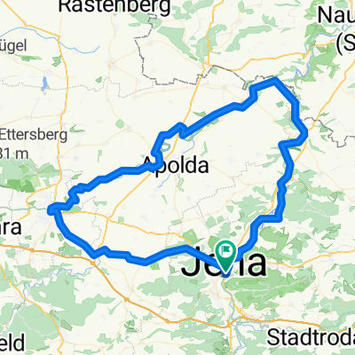
8. Tour - über den Fuchsturm nach Schöngleina
A cycling route starting in Jena, Thuringia, Germany.
Overview
About this route
- Start at the market square in Jena's city centre
- steep ascent on paved roads up to the Wilhelmshöhe inn (Burgweg 75) km 2.26
- further steep climb from there on normal hiking trails up to the local mountain. Two options: either via the yellow route on the south side of the mountain – with many stairs, steps and tight hairpins (hardly possible to cycle uphill here – better to push), but with a nice view into the Ziegehain valley; or the blue route on the north slope without steps, through beech forest, with no view into the valley in summer and over to the Jenzig. Both routes reunite again at the Fuchsturm.
- from here it gets easier, as the route has already reached the highest point. km 2.6
- past the Fuchsturm (medieval bergfried of one of the three local hill castles, inn with a cosy beer garden) km 3.54
- from the Fuchsturm again paved road up to the Steinkreuz km 5.5
- in between, a small detour through the forest to the valley edge with a nice view over the Ziegehain valley with 2 benches for resting (approx. 150m after the Fuchsturm turn right into the forest)
- here the official campfire site of the city of Jena with BBQ facilities
- from here you could also return down to Jena directly via the wooden path through Ziegenhain
- continue on compacted forest trails to the Luftschiff (former excursion inn, closed for years) km 7.8
- after around 11km we reach the back of the Schöngleina airfield
- opportunity to stop after 12.7km at the airfield restaurant
- then continue on paved road down to Schöngleina km 14.2
- then down into the valley to Lotschen
- continue through Schlöben and Gröben down to the A4
- on a field path towards Jena parallel to the motorway up to the Fairhotel and thus the urban area of Jena
- through the prefabricated housing estate Lobeda after 30km we reach the rest opportunity at the beer garden by the weir in Burgau
- after about 35km we are back in the city centre
- -:--
- Duration
- 35 km
- Distance
- 407 m
- Ascent
- 407 m
- Descent
- ---
- Avg. speed
- ---
- Max. altitude
Route highlights
Points of interest along the route

Point of interest after 2 km

Point of interest after 2 km

Point of interest after 2 km

Point of interest after 2.1 km

Point of interest after 2.2 km

Point of interest after 2.3 km

Point of interest after 2.4 km

Point of interest after 2.7 km

Point of interest after 2.8 km

Point of interest after 2.9 km

Point of interest after 2.9 km

Point of interest after 3 km

Point of interest after 3 km

Point of interest after 3 km

Point of interest after 3 km

Point of interest after 3.9 km
Fuchsturm

Point of interest after 3.9 km

Point of interest after 3.9 km

Point of interest after 3.9 km

Point of interest after 3.9 km
Fuchsturm

Point of interest after 6.1 km
Weg zum Luftschiff

Point of interest after 7 km

Point of interest after 8 km

Point of interest after 8 km

Point of interest after 8.1 km

Point of interest after 11.7 km

Point of interest after 12.9 km

Point of interest after 14.4 km

Point of interest after 14.4 km

Point of interest after 14.4 km

Point of interest after 14.5 km

Point of interest after 16.6 km

Point of interest after 16.6 km

Point of interest after 19.3 km

Point of interest after 19.4 km

Point of interest after 19.9 km

Point of interest after 20.1 km
Point of interest after 24.1 km
diesen Weg nicht langfahren, ist ne Sackgasse, die an einem sehr steilen Abhang endet

Point of interest after 24.7 km

Point of interest after 25.5 km

Point of interest after 26 km

Point of interest after 26.1 km

Point of interest after 26.7 km

Point of interest after 31.2 km

Point of interest after 31.2 km

Point of interest after 34.6 km
Continue with Bikemap
Use, edit, or download this cycling route
You would like to ride 8. Tour - über den Fuchsturm nach Schöngleina or customize it for your own trip? Here is what you can do with this Bikemap route:
Free features
- Save this route as favorite or in collections
- Copy & plan your own version of this route
- Sync your route with Garmin or Wahoo
Premium features
Free trial for 3 days, or one-time payment. More about Bikemap Premium.
- Navigate this route on iOS & Android
- Export a GPX / KML file of this route
- Create your custom printout (try it for free)
- Download this route for offline navigation
Discover more Premium features.
Get Bikemap PremiumFrom our community
Other popular routes starting in Jena
 8. Tour - über den Fuchsturm nach Schöngleina
- Distance
- 35 km
- Ascent
- 407 m
- Descent
- 407 m
- Location
- Jena, Thuringia, Germany
 Jena-Stadtroda-Jena
- Distance
- 34.6 km
- Ascent
- 280 m
- Descent
- 251 m
- Location
- Jena, Thuringia, Germany
 Jenzig- Kernberg Runde
- Distance
- 27.2 km
- Ascent
- 566 m
- Descent
- 566 m
- Location
- Jena, Thuringia, Germany
 SRW_Etappe6
- Distance
- 69.4 km
- Ascent
- 250 m
- Descent
- 391 m
- Location
- Jena, Thuringia, Germany
 Jena 1.Mai 2014
- Distance
- 36.7 km
- Ascent
- 295 m
- Descent
- 295 m
- Location
- Jena, Thuringia, Germany
 Romantik und Klassik per Rad
- Distance
- 92.5 km
- Ascent
- 577 m
- Descent
- 578 m
- Location
- Jena, Thuringia, Germany
 Von Jena bis Theißen
- Distance
- 57.3 km
- Ascent
- 541 m
- Descent
- 518 m
- Location
- Jena, Thuringia, Germany
 Feierabendrunde TPA
- Distance
- 38.5 km
- Ascent
- 443 m
- Descent
- 437 m
- Location
- Jena, Thuringia, Germany
Open it in the app