

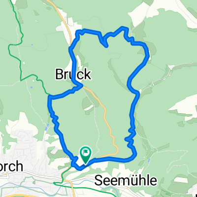
20141109_144305.gpx
A cycling route starting in Lorch, Baden-Wurttemberg, Germany.
Overview
About this route
TEASI track
- -:--
- Duration
- 25.9 km
- Distance
- 576 m
- Ascent
- 575 m
- Descent
- ---
- Avg. speed
- ---
- Max. altitude
Route quality
Waytypes & surfaces along the route
Waytypes
Track
11.9 km
(46 %)
Quiet road
8.3 km
(32 %)
Surfaces
Paved
17.6 km
(68 %)
Unpaved
6.2 km
(24 %)
Asphalt
16.8 km
(65 %)
Gravel
5.2 km
(20 %)
Continue with Bikemap
Use, edit, or download this cycling route
You would like to ride 20141109_144305.gpx or customize it for your own trip? Here is what you can do with this Bikemap route:
Free features
- Save this route as favorite or in collections
- Copy & plan your own version of this route
- Sync your route with Garmin or Wahoo
Premium features
Free trial for 3 days, or one-time payment. More about Bikemap Premium.
- Navigate this route on iOS & Android
- Export a GPX / KML file of this route
- Create your custom printout (try it for free)
- Download this route for offline navigation
Discover more Premium features.
Get Bikemap PremiumFrom our community
Other popular routes starting in Lorch
 Lorch-Haselbach
- Distance
- 18.6 km
- Ascent
- 291 m
- Descent
- 294 m
- Location
- Lorch, Baden-Wurttemberg, Germany
 Lorch-Schorndorf-Lorch
- Distance
- 37.3 km
- Ascent
- 399 m
- Descent
- 404 m
- Location
- Lorch, Baden-Wurttemberg, Germany
 Hohbergrunde
- Distance
- 23.5 km
- Ascent
- 536 m
- Descent
- 469 m
- Location
- Lorch, Baden-Wurttemberg, Germany
 gemuetliche Runde
- Distance
- 34.4 km
- Ascent
- 461 m
- Descent
- 492 m
- Location
- Lorch, Baden-Wurttemberg, Germany
 Walkersbach Bärenbach Badeseen - Walkersbach Bärenbach Badeseen
- Distance
- 19.9 km
- Ascent
- 344 m
- Descent
- 344 m
- Location
- Lorch, Baden-Wurttemberg, Germany
 Klingen
- Distance
- 10.5 km
- Ascent
- 358 m
- Descent
- 358 m
- Location
- Lorch, Baden-Wurttemberg, Germany
 Alte Trasse
- Distance
- 49.8 km
- Ascent
- 520 m
- Descent
- 520 m
- Location
- Lorch, Baden-Wurttemberg, Germany
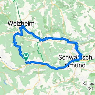 Vier Täler Tour bei Welzheim
- Distance
- 51.3 km
- Ascent
- 427 m
- Descent
- 428 m
- Location
- Lorch, Baden-Wurttemberg, Germany
Open it in the app