

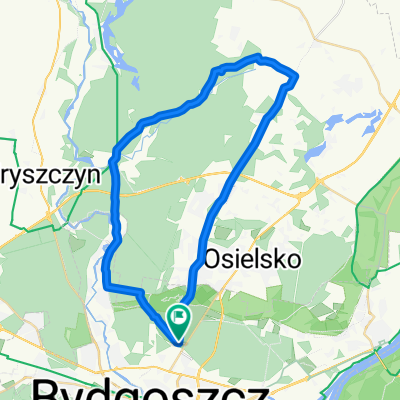
Błonie - Fordon-Błonie
A cycling route starting in Bydgoszcz, Kujawsko-Pomorskie Voivodship, Poland.
Overview
About this route
02.12.2014
- -:--
- Duration
- 30.7 km
- Distance
- 57 m
- Ascent
- 60 m
- Descent
- ---
- Avg. speed
- ---
- Max. altitude
Route quality
Waytypes & surfaces along the route
Waytypes
Road
7.7 km
(25 %)
Quiet road
4.9 km
(16 %)
Surfaces
Paved
16.3 km
(53 %)
Unpaved
0.3 km
(1 %)
Asphalt
15.7 km
(51 %)
Paved (undefined)
0.3 km
(1 %)
Route highlights
Points of interest along the route
Point of interest after 6.5 km
Kurs nauki latania przez kierownicę...
Continue with Bikemap
Use, edit, or download this cycling route
You would like to ride Błonie - Fordon-Błonie or customize it for your own trip? Here is what you can do with this Bikemap route:
Free features
- Save this route as favorite or in collections
- Copy & plan your own version of this route
- Sync your route with Garmin or Wahoo
Premium features
Free trial for 3 days, or one-time payment. More about Bikemap Premium.
- Navigate this route on iOS & Android
- Export a GPX / KML file of this route
- Create your custom printout (try it for free)
- Download this route for offline navigation
Discover more Premium features.
Get Bikemap PremiumFrom our community
Other popular routes starting in Bydgoszcz
 Wokół Zalewu Koronowskiego
- Distance
- 103.9 km
- Ascent
- 215 m
- Descent
- 213 m
- Location
- Bydgoszcz, Kujawsko-Pomorskie Voivodship, Poland
 Dookoła osielska, przez fordon
- Distance
- 53.7 km
- Ascent
- 141 m
- Descent
- 141 m
- Location
- Bydgoszcz, Kujawsko-Pomorskie Voivodship, Poland
 15km - Dąbrowa Las
- Distance
- 15.3 km
- Ascent
- 77 m
- Descent
- 76 m
- Location
- Bydgoszcz, Kujawsko-Pomorskie Voivodship, Poland
 Pętelka Pyszczyn
- Distance
- 38.5 km
- Ascent
- 168 m
- Descent
- 168 m
- Location
- Bydgoszcz, Kujawsko-Pomorskie Voivodship, Poland
 Bydgoszcz Cycling
- Distance
- 30.8 km
- Ascent
- 24 m
- Descent
- 24 m
- Location
- Bydgoszcz, Kujawsko-Pomorskie Voivodship, Poland
 NIEDZIELNY TRENING
- Distance
- 24 km
- Ascent
- 67 m
- Descent
- 69 m
- Location
- Bydgoszcz, Kujawsko-Pomorskie Voivodship, Poland
 Tour de Myślęcinek etap 3
- Distance
- 15.8 km
- Ascent
- 60 m
- Descent
- 58 m
- Location
- Bydgoszcz, Kujawsko-Pomorskie Voivodship, Poland
 Jana Kozietulskiego 9, Bydgoszcz do Jana Kozietulskiego 9, Bydgoszcz
- Distance
- 18.9 km
- Ascent
- 87 m
- Descent
- 78 m
- Location
- Bydgoszcz, Kujawsko-Pomorskie Voivodship, Poland
Open it in the app