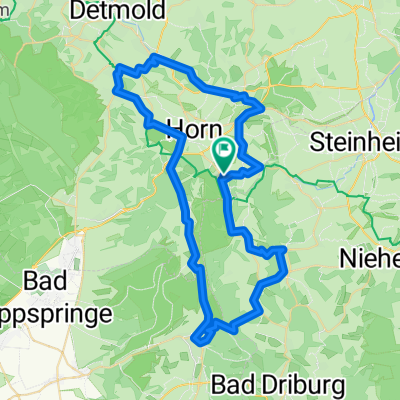
Eggeweg komplett nach Garmin Topo Deutschland
A cycling route starting in Horn, North Rhine-Westphalia, Germany.
Overview
About this route
- -:--
- Duration
- 71.6 km
- Distance
- 916 m
- Ascent
- 800 m
- Descent
- ---
- Avg. speed
- ---
- Max. altitude
Continue with Bikemap
Use, edit, or download this cycling route
You would like to ride Eggeweg komplett nach Garmin Topo Deutschland or customize it for your own trip? Here is what you can do with this Bikemap route:
Free features
- Save this route as favorite or in collections
- Copy & plan your own version of this route
- Sync your route with Garmin or Wahoo
Premium features
Free trial for 3 days, or one-time payment. More about Bikemap Premium.
- Navigate this route on iOS & Android
- Export a GPX / KML file of this route
- Create your custom printout (try it for free)
- Download this route for offline navigation
Discover more Premium features.
Get Bikemap PremiumFrom our community
Other popular routes starting in Horn
- Velmerstot to Externsteine
- Distance
- 21.2 km
- Ascent
- 513 m
- Descent
- 504 m
- Location
- Horn, North Rhine-Westphalia, Germany
- Wandern Eggeweg Etappe 01
- Distance
- 25.2 km
- Ascent
- 431 m
- Descent
- 487 m
- Location
- Horn, North Rhine-Westphalia, Germany
- Externsteine - Hermannsdenkmal - Detmold - Bad Meinberg - Horn
- Distance
- 40.3 km
- Ascent
- 629 m
- Descent
- 708 m
- Location
- Horn, North Rhine-Westphalia, Germany
- Dillenkamp nach Nordstraße
- Distance
- 31.3 km
- Ascent
- 563 m
- Descent
- 608 m
- Location
- Horn, North Rhine-Westphalia, Germany
- Hermannsweg von Bad Meinberg bis Bielefelder Alm
- Distance
- 42.2 km
- Ascent
- 901 m
- Descent
- 973 m
- Location
- Horn, North Rhine-Westphalia, Germany
- Externsteine bis Xantener Südsee
- Distance
- 348 km
- Ascent
- 765 m
- Descent
- 985 m
- Location
- Horn, North Rhine-Westphalia, Germany
- Externsteine bis Xantener Südsee
- Distance
- 315.6 km
- Ascent
- 1,017 m
- Descent
- 1,250 m
- Location
- Horn, North Rhine-Westphalia, Germany
- 26 Runde Vahlhsn-Fknick-DBruch-HOdorf
- Distance
- 26 km
- Ascent
- 270 m
- Descent
- 277 m
- Location
- Horn, North Rhine-Westphalia, Germany
Open it in the app