
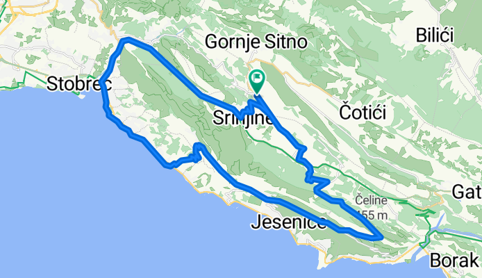
Sitno - Tugare - Stomorica - Duće - Jesenice - Gornja Podstana
A cycling route starting in Srinjine, Splitsko-Dalmatinska Županija, Croatia.
Overview
About this route
Kreće se iz Sitnog prema Podumima - dio Tugara. Od tuda laganim usponom se prolazi kroz eko-etno selo Čažin Dolac, do župne crkve u Tugarima,odakle se nastavlja spustom do Truša. Od Truša je maladamski uspon do kapele Gospe od Snjiga na Stomorice. Pa se prušta kozjom stazom do Gornjih Duća. Od tuda je spust kroz stara Jesenička sela Zeljoviće, Krug...pa sve do Gornje Podstrane.
- -:--
- Duration
- 36.9 km
- Distance
- 689 m
- Ascent
- 691 m
- Descent
- ---
- Avg. speed
- ---
- Avg. speed

Continue with Bikemap
Use, edit, or download this cycling route
You would like to ride Sitno - Tugare - Stomorica - Duće - Jesenice - Gornja Podstana or customize it for your own trip? Here is what you can do with this Bikemap route:
Free features
- Save this route as favorite or in collections
- Copy & plan your own version of this route
- Sync your route with Garmin or Wahoo
Premium features
Free trial for 3 days, or one-time payment. More about Bikemap Premium.
- Navigate this route on iOS & Android
- Export a GPX / KML file of this route
- Create your custom printout (try it for free)
- Download this route for offline navigation
Discover more Premium features.
Get Bikemap PremiumFrom our community
Other popular routes starting in Srinjine
 Gata - Sitno - Korešnica
- Distance
- 44.8 km
- Ascent
- 999 m
- Descent
- 999 m
- Location
- Srinjine, Splitsko-Dalmatinska Županija, Croatia
 Sitno - Gata - Omiš - Podstrana
- Distance
- 48.6 km
- Ascent
- 598 m
- Descent
- 602 m
- Location
- Srinjine, Splitsko-Dalmatinska Županija, Croatia
 Cool!
Cool!- Distance
- 42.4 km
- Ascent
- 1,056 m
- Descent
- 1,056 m
- Location
- Srinjine, Splitsko-Dalmatinska Županija, Croatia
 Stomorica - Stara Podstrana - Sv. Jure - Zrnovnica
- Distance
- 39.4 km
- Ascent
- 886 m
- Descent
- 886 m
- Location
- Srinjine, Splitsko-Dalmatinska Županija, Croatia
 Mosor orijentacijski 3
- Distance
- 3.6 km
- Ascent
- 250 m
- Descent
- 250 m
- Location
- Srinjine, Splitsko-Dalmatinska Županija, Croatia
 Nediljni đir
- Distance
- 7.1 km
- Ascent
- 562 m
- Descent
- 563 m
- Location
- Srinjine, Splitsko-Dalmatinska Županija, Croatia
 Trail Poljica
- Distance
- 57 km
- Ascent
- 1,190 m
- Descent
- 1,190 m
- Location
- Srinjine, Splitsko-Dalmatinska Županija, Croatia
 Zakon
Zakon- Distance
- 41.2 km
- Ascent
- 812 m
- Descent
- 812 m
- Location
- Srinjine, Splitsko-Dalmatinska Županija, Croatia
Open it in the app