

🇯🇵 JPN D12b - YOKOHAMA
A cycling route starting in Fujikawaguchiko, Yamanashi, Japan.
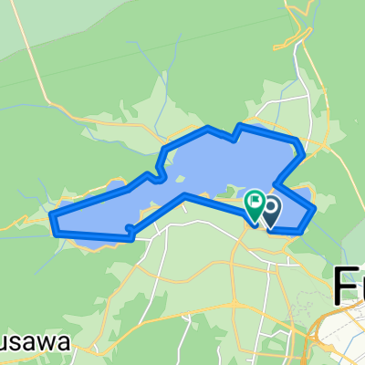
Overview
About this route
Dzień12b Yokohama + krótki spacer po Shinjuku + powrót do Tokyo Kashiwa
Środki transportu:
Kolej Fuji: 27km
JR kolej: 160km
Pieszo: 11+3+1,5 = 15,5km
Punkt widokowy w Yokohamie - wys. 273m
- -:--
- Duration
- 210.2 km
- Distance
- 489 m
- Ascent
- 1,330 m
- Descent
- ---
- Avg. speed
- ---
- Max. altitude

Continue with Bikemap
Use, edit, or download this cycling route
You would like to ride 🇯🇵 JPN D12b - YOKOHAMA or customize it for your own trip? Here is what you can do with this Bikemap route:
Free features
- Save this route as favorite or in collections
- Copy & plan your own version of this route
- Split it into stages to create a multi-day tour
- Sync your route with Garmin or Wahoo
Premium features
Free trial for 3 days, or one-time payment. More about Bikemap Premium.
- Navigate this route on iOS & Android
- Export a GPX / KML file of this route
- Create your custom printout (try it for free)
- Download this route for offline navigation
Discover more Premium features.
Get Bikemap PremiumFrom our community
Other popular routes starting in Fujikawaguchiko
 20241027_奥富士ロングライド
- Distance
- 55 km
- Ascent
- 1,784 m
- Descent
- 1,785 m
- Location
- Fujikawaguchiko, Yamanashi, Japan
 5 Lakes of Fuji mike
- Distance
- 131.3 km
- Ascent
- 649 m
- Descent
- 1,387 m
- Location
- Fujikawaguchiko, Yamanashi, Japan
 Yamanaka Lake to Fuji river
- Distance
- 149.5 km
- Ascent
- 2,518 m
- Descent
- 3,222 m
- Location
- Fujikawaguchiko, Yamanashi, Japan
 Mt Fuji Subaru line
- Distance
- 23.5 km
- Ascent
- 1,222 m
- Descent
- 0 m
- Location
- Fujikawaguchiko, Yamanashi, Japan
 富士山 伊豆 熱海 伊東
- Distance
- 100.7 km
- Ascent
- 856 m
- Descent
- 1,696 m
- Location
- Fujikawaguchiko, Yamanashi, Japan
 6713-3 to 6713-6
- Distance
- 15.1 km
- Ascent
- 20 m
- Descent
- 56 m
- Location
- Fujikawaguchiko, Yamanashi, Japan
 20181028fuji-2
- Distance
- 68.2 km
- Ascent
- 512 m
- Descent
- 508 m
- Location
- Fujikawaguchiko, Yamanashi, Japan
 kawaguchi and fujikyu
- Distance
- 26 km
- Ascent
- 389 m
- Descent
- 391 m
- Location
- Fujikawaguchiko, Yamanashi, Japan
Open it in the app