

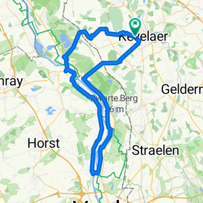
Big Challenge Lauf "Rund um Winnekendonk" 2023
A cycling route starting in Kevelaer, North Rhine-Westphalia, Germany.
Overview
About this route
Big Challenge 2023:
Strecke für Läufer. Schaffe eine oder mehrere Runden für den guten Zweck. "Aufgeben ist keine Option".
- -:--
- Duration
- 8 km
- Distance
- 0 m
- Ascent
- 0 m
- Descent
- ---
- Avg. speed
- ---
- Max. altitude
Route quality
Waytypes & surfaces along the route
Waytypes
Quiet road
3.5 km
(43 %)
Path
3.1 km
(39 %)
Surfaces
Paved
5.9 km
(73 %)
Asphalt
3.9 km
(49 %)
Paving stones
1.9 km
(24 %)
Undefined
2.1 km
(27 %)
Continue with Bikemap
Use, edit, or download this cycling route
You would like to ride Big Challenge Lauf "Rund um Winnekendonk" 2023 or customize it for your own trip? Here is what you can do with this Bikemap route:
Free features
- Save this route as favorite or in collections
- Copy & plan your own version of this route
- Sync your route with Garmin or Wahoo
Premium features
Free trial for 3 days, or one-time payment. More about Bikemap Premium.
- Navigate this route on iOS & Android
- Export a GPX / KML file of this route
- Create your custom printout (try it for free)
- Download this route for offline navigation
Discover more Premium features.
Get Bikemap PremiumFrom our community
Other popular routes starting in Kevelaer
 Twisteden, Well, Witte Vennen, Broekhuizen
- Distance
- 51.6 km
- Ascent
- 77 m
- Descent
- 77 m
- Location
- Kevelaer, North Rhine-Westphalia, Germany
 Ausfahrt über Wenn
- Distance
- 20.4 km
- Ascent
- 29 m
- Descent
- 30 m
- Location
- Kevelaer, North Rhine-Westphalia, Germany
 Arcen Faehre
- Distance
- 45.4 km
- Ascent
- 59 m
- Descent
- 57 m
- Location
- Kevelaer, North Rhine-Westphalia, Germany
 Ich will "" MEER ""
- Distance
- 239.8 km
- Ascent
- 38 m
- Descent
- 61 m
- Location
- Kevelaer, North Rhine-Westphalia, Germany
 Xanten-Öbermörmter-Uedem über Kirsel
- Distance
- 59.4 km
- Ascent
- 100 m
- Descent
- 103 m
- Location
- Kevelaer, North Rhine-Westphalia, Germany
 An der Maas entlang
- Distance
- 59.7 km
- Ascent
- 61 m
- Descent
- 60 m
- Location
- Kevelaer, North Rhine-Westphalia, Germany
 Photo Safari mit Mölle
- Distance
- 150.8 km
- Ascent
- 83 m
- Descent
- 86 m
- Location
- Kevelaer, North Rhine-Westphalia, Germany
 Schauen wir mal :-)
- Distance
- 157.7 km
- Ascent
- 99 m
- Descent
- 99 m
- Location
- Kevelaer, North Rhine-Westphalia, Germany
Open it in the app